Identifying edges with Humminbird Side Imaging

  • jhalfen
    Posts: 4179
    #1294851

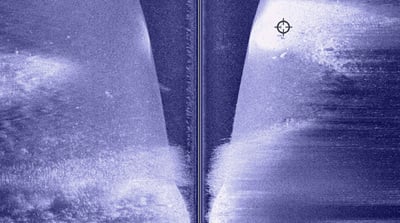
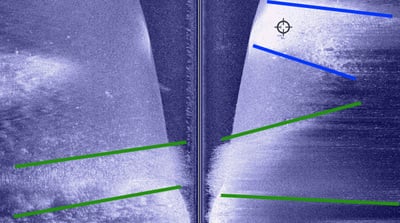
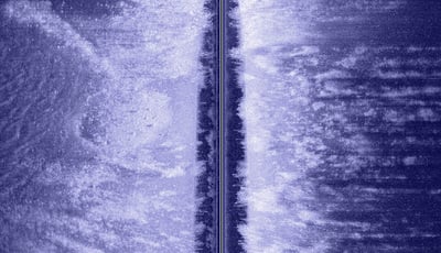
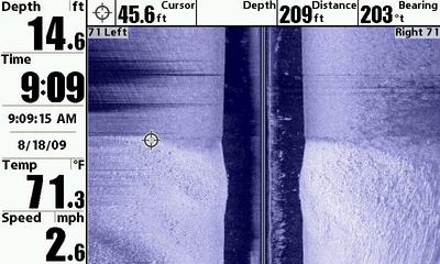
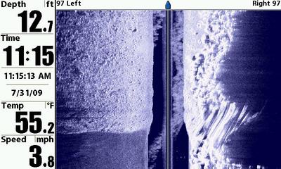
    One of the most powerful capabilities of Humminbird’s industry-leading Side Imaging technology is its ability to clearly identify structure edges, or said another way, transitions from one type of structure/bottom content to another. I thought we’d take a quick look at a piece of structure that has several such transitions, and see how easily Humminbird’s Side Imaging locators can identify these edges.

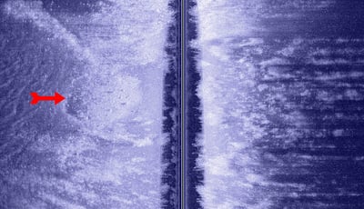
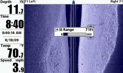
    Check out the screen capture below. I collected it while moving off a shallow, weedy bar into deeper water. The depth at the top of the screen capture is ~ 50 feet, while it is more like 3-5 at the bottom.

    jhalfen
    Posts: 4179
    #797267

    The first edge I want to point out to you is noted with green lines in the image below. These green lines denote the edges of a band of cabbage weeds growing on bar as it breaks into deeper water. The cabbage band starts at about 6 feet and grows out to 12 feet….then cleanly stops, forming a well-defined structure edge that anglers target for bass, walleye, and musky.

    The second set of edges are towards the top of the image, marked with blue lines. They reflect the transition between an isolated rock bar (marked with the cursor) and the surrounding soft bottom. The rock bar starts in ~ 12 feet of water and extends out to 20-25 feet. Think any walleyes or smallies might use this bar? I never knew this rockbar existed until I imaged it with my Humminbird 1197….and I’ve had the chance to revisit it several times this summer with great success!

    jhalfen
    Posts: 4179
    #797268

    Here’s a different portion of that shallow weedy bar, shown with a split screen; traditional 2D sonar on the left and side imaging on the right.

    Check out the brown vertical lines on the 2D portion; they reflect the well-defined band of cabbage growing on the break of the bar. That same band can be seen on the Side Imaging view on the right, also noted with brown lines.

    jhalfen
    Posts: 4179
    #797269

    Once a guy recognizes what cabbage looks like in Side Imaging, it’s easy to see other bands of cabbage growing on the same bar. I’ve marked another band in the image below.

    For comparison, I included the image shown in the post above. If you look carefully, you can see the transition from the junk weeds on top of the bar to the cabbage bed…it looks like a dark line at the lower (shallow; inner) edge of the cabbage. Cursor back and forth between the two images; you’ll see what I’m talking about.

    jhalfen
    Posts: 4179
    #797270

    One more edge to check out….or rather, one more transition between structure types.

    This screen capture is of a shallow flat that has scattered clumps of cabbage and coontail over a relatively soft bottom. There is one area of this flat that consistently holds active, catchable walleyes, particularly after dark in the early part of the season. Can you pick it out?

    jhalfen
    Posts: 4179
    #797273

    Here it is…noted by the red arrow on the left side of the image. An isolated area of gravel, about 20′ x 20′. We never knew why fish held in this specific area until we had a chance to image it with my Humminbird 1197. Now we know why….walleyes are relating to the gravel patch and the transition between hard and the surrounding soft bottom.

    With fall trolling season coming up soon, we’ll all be reminded time and time again about the importance of transition areas….boundaries between rock and sand, between sand and weeds, between weeds and rock, etc etc. If you’re wondering how to find and target these areas, wonder no longer: Humminbird Side Imaging fishing systems are your answer.

    KirtH
    Lakeville
    Posts: 4063
    #797277

    I also found the SI awsome when trying to troll weed edges, you can follow the edge perfectly when watching the SI, you see the weedline coming out, you can steer outward away from the weeds, then when it starts moving away you can steer inward. No more crashing into the weeds or guessing when and where it will change directions

    whittsend
    Posts: 2389
    #797292

    Quote:


    I also found the SI awsome when trying to troll weed edges, you can follow the edge perfectly when watching the SI, you see the weedline coming out, you can steer outward away from the weeds, then when it starts moving away you can steer inward. No more crashing into the weeds or guessing when and where it will change directions


    Weededges, dropoffs, old river or creek channels… Works AWESOME for those applications.

    Here are a few images with easy to identify edges…

    1 Boat heading down the dropoff

    2 Sand edge on the far right, closer to shore. Also a man-made edge (sunken bridge or road)

    3 Weeds topping out, then tapering out along the droppoff

    4 Boat heading into shallower water – all soft bottom, but shallower sections are shaded lighter

    5 Boat traveling down the dropoff. More distinct drops on the right side of the screen, fish holding on the upper part of the drop.

    Sweet images and explanations, Jason… Thanks!


    Calvin Svihel
    Moderator
    Northwest Metro, MN
    Posts: 3862
    #797293

    Great information. I look forward to using one of these this fall.

    nic-habeck
    Lake Mills, WI
    Posts: 831
    #797339

    Whittsend, the resolution on those pics are amazing, were those shot on a really crystal clear lake?

    jhalfen
    Posts: 4179
    #797341

    I’m pretty sure that those were shot on Wissota, but I’ll let Mike confirm that.

    Wissota isn’t what I’d classify as crystal clear

    absolute2ks
    Chippewa Falls, WI
    Posts: 674
    #797354

    I beleve that image 2 is a RR bridge

    whittsend
    Posts: 2389
    #797505

    Yup, Wissota… And yes, I think its a RR bridge too. Used to be the old tracks that ran out of Anson accross what used to be the yellow river, prior to the flooding around 1918 (?) Same set that Jason has pics of, just further of the line. Jason posted the actual tracks/raised track line/and even a small bridge earlier this year…

    No, wissota isnt your typical clearwater lake… just a “touch” murky..

    Mike

    whittsend
    Posts: 2389
    #800239

    Finally got my most recent SI images off of the unit… Here are a few more edges….

    First ones are rock / soft area transitions. A few have the shoreline, weed clumps, or other “edges” shown. You can very clearly see the gravel / rock areas vs soft bottom.


    whittsend
    Posts: 2389
    #800240

    Here is the breakwall boulder in PW. you can see the abrupt rock to soft area transition as well as the individual boulders in the breakwall.

    whittsend
    Posts: 2389
    #800243

    Here are some “edges” of baitfish pods… The SI shot is in the harbor, I ran right over the top of it. (Note also all of the other fish present) The down sonar is out in the lake…

    The last shot is of a pod of kings. Very clear with the 2d what depth they are at, and where I might want to run my baits. You can also see my cannonball in many of these down images.


    jhalfen
    Posts: 4179
    #800249

    Cool images Mike.

    I was just wondering today how your 997 handled your Great Lakes trips. I see that it handled the big water just fine!

    whittsend
    Posts: 2389
    #800255

    Yup, went well. Marked my cannonballs constantly, marked lots of fish, and the SI marked some fish as well. I found myself not paying as much attention to the SI since I wanted to know where my canonballs were in relation to fish under the boat – So I didn’t get very many cool SI shots of fish… But I did throw in a few SI images with kings on the bottom or somewhat suspended…

    Mike

Viewing 18 posts - 1 through 18 (of 18 total)

You must be logged in to reply to this topic.