Some things you would like to see changed?

  • KirtH
    Lakeville
    Posts: 4063
    #1294861

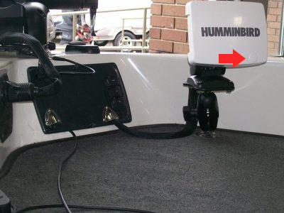
    I think Humminbirds are top notch, but there are a couple of things that would be nice to see.

    Pysically change the size of the display didgets. The temp doesnt need to be as big as the depth. I know you can change the tenths. Maybe give us small medium and large display choices

    Being able to select all the display readouts on all screens, carry the same from the depth screen to the gps screen

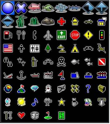
    When you select the icon on the gps screen have them all pop up rather than screen thru them all.

    jhalfen
    Posts: 4179
    #800355

    Interesting ideas, Kirt. I’ll make sure that the guys at HB check this thread out.

    Guys, if you have other recommendations, please add them below. Thanks!

    whittsend
    Posts: 2389
    #800362

    Updating the temperature graph on the 2D screen to be either user-selectable as far a range, or just set it and forget it at a 5 degree range. 20 degree ranges will give you a flat line every single time under most normal surface temp change conditions, and won’t help at all to detect more subtle half to 2-3 degree surface temp changes…

    Also discussed here: http://www.idofishing.com/forum/showflat.php/Number/814182/fpart/1/more-fish-pics

    Mike

    Randy Wieland
    Lebanon. WI
    Posts: 13297
    #800387

    Jason, I gave my wish list this year to the engineers and got an “Oh Boy….” Maybe you will have better results LOL

    For the 1197

    polarized screen engineered to refract light at 45 degree in lieu of 90 degrees like a typical polarizing lens

    touch screen with static mat over 3/8 thick screen for all tracking, routing, and zoom features

    True video output to a sealed F connector

    True video input to a sealed F connector and a 1/4 screen aux input display.

    Water proof USB port for aditional aux input

    cell phone interface for instant texting of screen capture

    6 more charaters for waypoint names in the display

    Standard built in 10 channel weather alert radio with auto scan for the 3 strongest signals ( not the XM Radio )

    and my daughters want to know where to plug in their Ipod (I really don’t want this one….I don’t like their music)

    carroll58
    Twin Cities, USA
    Posts: 2094
    #800390

    A Truely smart unit with Smart Lakemaps.

    Getting Maps that have the Lake Elevation tagged and then a place to enter the distance from your GPS Antenna to the water to have the actual water elevation in your map and smart by having the unit then process the map/lake bottom data into current contours.

    This way when you on on lakes/resovours that fluctuate, the contours would be a true current representation. Especially for the Big Lake that they draw down like Powell or Mead out on the Colorado. Would be great on even some smaller lakes as I have been on a few that were down 3-4 ft this summer.

    ottomatica
    Lino Lakes, MN
    Posts: 1380
    #800442

    Quote:


    A Truely smart unit with Smart Lakemaps.

    Getting Maps that have the Lake Elevation tagged and then a place to enter the distance from your GPS Antenna to the water to have the actual water elevation in your map and smart by having the unit then process the map/lake bottom data into current contours.

    This way when you on on lakes/resovours that fluctuate, the contours would be a true current representation. Especially for the Big Lake that they draw down like Powell or Mead out on the Colorado. Would be great on even some smaller lakes as I have been on a few that were down 3-4 ft this summer.


    The new Lakemaster maps are supposed to do that. I think you would set the fluctuation manually.

    ottomatica
    Lino Lakes, MN
    Posts: 1380
    #800443

    Here’s my list of things I’ve asked from Lowrance. From what I’ve seen it seems like Humminbird is more receptive to giving the user more control. I have a 1st generation SI unit so maybe some of this stuff is already there.

    1. A latch for the cover (what’s the sense of having a cover if it’s not designed to be mounted while towing?)
    2. More fishing orientated icons. i.e. Rocks weeds stumps cribs reefs baitfish big fish medium fish walleye bass etc…
    3. On the same note, how about custom icons?
    4. How about adding sensor data to GPS waypoints, i.e. when you set a waypoint, it will capture all connected sensor data i.e. transducer temp, barometer, air tem…etc.
    5. How about a user database with an interface to store typical waypoint data, i.e. species of fish, size of fish, structure etc. For example: If I catch a fish, I would set a waypoint and a menu would immediately pop up allowing me to save data related to this waypoint, so, I would click, waypoint type = caught fish, then knowing that it is fish data it would pop up fishing related data entry options like species = walleye, length = 17″, lure = taildancer, structure = reef, the list could go on and on and should be customizable to a point. The would make logging your fishing experience much easier.
    6. More customizable user interface options.
    7. Fish counter
    8. User API where users can create their own applications to control the functionality of the unit.

    carroll58
    Twin Cities, USA
    Posts: 2094
    #800445

    The new Lakemaster maps are supposed to do that. I think you would set the fluctuation manually.


    Thanks, I heard some talk but have not took time to check them out yet. Have to do that this winter.

    jhalfen
    Posts: 4179
    #800454

    Some of the thins you’re interested in are available in the current run of Side Imaging units, and others will likely be present, in some form, in the 2010 units.

    For example:

    Quote:


    1. A latch for the cover (what’s the sense of having a cover if it’s not designed to be mounted while towing?)


    The new units have a modified cover that have a really snug fit. They have a small “button” on the lower right, noted by the red arrow in this picture, that you have to push to get the cover off the unit. I trailer my boat at highway speeds, and have yet to lose a cover from one of my Humminbird units, even the 788 at the bow that is quite exposed and catches a lot of wind.

    jhalfen
    Posts: 4179
    #800456

    Quote:


    2. More fishing orientated icons. i.e. Rocks weeds stumps cribs reefs baitfish big fish medium fish walleye bass etc…


    Many of these are available in Humminbird PC, a fantastic waypoint management tool. To learn more about Humminbird PC, check out this link:

    Waypoint management with Humminbird PC

    New waypoint management tools are also due out with the 2010 Humminbird units.

    ottomatica
    Lino Lakes, MN
    Posts: 1380
    #800518

    Quote:


    Quote:


    2. More fishing orientated icons. i.e. Rocks weeds stumps cribs reefs baitfish big fish medium fish walleye bass etc…


    Many of these are available in Humminbird PC, a fantastic waypoint management tool. To learn more about Humminbird PC, check out this link:

    Waypoint management with Humminbird PC

    New waypoint management tools are also due out with the 2010 Humminbird units.


    I have Humminbird PC but it doesn’t really look like they have all that many icons. The new Lowrance units have a pretty good selection of waypoint icons…still missing some in my opinion but better than before and better than Humminbird from what I’ve seen.

    Also add to the list:

    – Digital Compass input to orient your GPS map to the boats actual angle, not the GPS determined angle. This is good for when you’re on the trolling motor and hovering on a spot it would be very nice to have the map oriented with the boat.

    – Waypoint filtering – filter visible waypoints by type, time, etc.

    ottomatica
    Lino Lakes, MN
    Posts: 1380
    #800527

    Here are Lowrance Icons. You can also customize the color of the icon in the upper left.

    One more feature request, maybe it’s already there:

    – Project a predefined radius on the GPS screen around your current position. You would use this to be able to judge your distance from waypoints or contour lines on the map. i.e. a 50ft radius would tell you that your are within casting distance of a waypoint.

    whittsend
    Posts: 2389
    #800537

    Quote:


    Here are Lowrance Icons. You can also customize the color of the icon in the upper left.

    One more feature request, maybe it’s already there:

    – Project a predefined radius on the GPS screen around your current position. You would use this to be able to judge your distance from waypoints or contour lines on the map. i.e. a 50ft radius would tell you that your are within casting distance of a waypoint.


    I know they have option with trolling grids and bullseyes around a target or the boat maybe.. haven’t played with it much, but that capability might be built in already??

    ottomatica
    Lino Lakes, MN
    Posts: 1380
    #800540

    Bullseye around the boat would work…

    whittsend
    Posts: 2389
    #800542

    I know you can select a waypoint or spot on the map and it will give you a running account of distance to target….

    whittsend
    Posts: 2389
    #800560

    That downscan imaging that Lowrance has looks interesting… I’m not sure its really any more helpful than the HB SI, but its a unique feature nonetheless…

    Mike

    nic-habeck
    Lake Mills, WI
    Posts: 831
    #800694

    Ability to customize overlay data however you want. I get really frustrated with my 788ci mounted on my bow. When I run the split screen with GPS/Sonar it always needs to display position and orientation. I would rather have time and water temp and I should be able to make that choice.

    KirtH
    Lakeville
    Posts: 4063
    #800712

    Quote:


    Ability to customize overlay data however you want. I get really frustrated with my 788ci mounted on my bow. When I run the split screen with GPS/Sonar it always needs to display position and orientation. I would rather have time and water temp and I should be able to make that choice.


    reddog
    Posts: 801
    #801748

    “User created default” menu tab.

    When I set my unit up the way I want it and have everything optimized for viewing, I wish I could save it as my own personal default setting.

    Whenever you have to make a change or an update, you should go to the units defaults to load the updates, but it would be nice if after I was done, that I could scroll to the menu item below the restore factory defaults, and select the “restore user created default”

Viewing 19 posts - 1 through 19 (of 19 total)

You must be logged in to reply to this topic.