Time to pull off the Island

  • Brian Klawitter
    Keymaster
    Minnesota/Wisconsin Mississippi River
    Posts: 59944
    #1770162

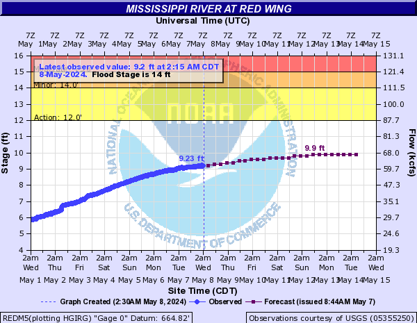
    I would have bet a quarter that the Red Wing gauge wouldn’t make it past 10-11′ before cresting (unless it rained).

    Of course I was wrong and with 13′ projected from Monday and no crest in sight, it’s time to hook up the ol camper and head to higher ground.

    At 13′ my tires will get wet and that’s ok…just that there’s going to be 2′ of water to get back to my campsite. I need a kayak. crazy

    Evan Pheneger
    Hastings, MN
    Posts: 838
    #1770178

    You would be quarterless… whenever I picture you floating…and trust me I don’t picture it often.

    It looks something like this… Maybe you could use that to get out to the camper…

    Attachments:
    1. BK-headed-to-his-camper.jpg

    Brian Klawitter
    Keymaster
    Minnesota/Wisconsin Mississippi River
    Posts: 59944
    #1770184

    I’ll just wait for your nice toon to float down stream to me. Make sure the gas tank is full please.

    FYI:

    The ramp at Colvill closes at about 12 feet and the Bay Point ramp closes at about 13. Colvill will probably close on Monday and Bay Point sometime next week if the river continues to rise. Thanks

    Lynn Nardinger | Deputy Director Public Services
    Public Works Department
    Streets, Underground Utilites, Fleet Maintenance, Marina
    City of Red Wing | http://www.red-wing.org

    Evan Pheneger
    Hastings, MN
    Posts: 838
    #1770186

    Good info BK, For any crazy person who wants to hit the river in flood stage I will open my backyard up to launching at 13′ aka 17.5′ (in hastings) )

    Brian Klawitter
    Keymaster
    Minnesota/Wisconsin Mississippi River
    Posts: 59944
    #1770188

    You are a good man Evan!

    Evan Pheneger
    Hastings, MN
    Posts: 838
    #1770192

    I would assume the Hastings Public launch does not close? I would guess that can handle some high water with the slope to launch.

    Any idea on that BK?

    Brian Klawitter
    Keymaster
    Minnesota/Wisconsin Mississippi River
    Posts: 59944
    #1770201

    Not really.

    I can’t recall it being closed off in years past but I don’t pay much attention to that area.

    I would think the current would make it difficult to load or launch there(?)

    munchy
    NULL
    Posts: 4686
    #1770207

    I’ve seen Hastings close a couple times when the water gets high enough to hit the road. But that’s more because the road getting down there is closed, and that’s been at least 10 years.

    404 ERROR
    MN
    Posts: 3918
    #1770211

    I would assume the Hastings Public launch does not close? I would guess that can handle some high water with the slope to launch.

    Any idea on that BK?

    I’m not BK, but I believe they would have to close the ramp because of the road around 19-20′ in Hastings. Decently good chance that could happen this year. I remember launching there in June a few years back and I think it was in the high 17’s at the time and it was getting close to the road but the ramp was open.

    Brian Klawitter
    Keymaster
    Minnesota/Wisconsin Mississippi River
    Posts: 59944
    #1770215

    36.6′ Prairie Island power plant may go to an emergency state to prepare for flooding.
    29.5′ Prairie Island power plant may go to an alert state to prepare for flooding.
    23′ Highway 10 at Point Douglas may be closed due to safety concerns.
    20.39′ Lock and dam 2 may end operations.
    20′ Flooding begins at Point Douglas.
    19′ Flood waters begin to affect eastern portions of Hastings.

    munchy
    NULL
    Posts: 4686
    #1770217

    36.6′ Prairie Island power plant may go to an emergency state to prepare for flooding.
    29.5′ Prairie Island power plant may go to an alert state to prepare for flooding.

    Have those marks ever been hit?

    Bassn Dan
    Posts: 967
    #1770218

    Usually NOAA way overshoots the top end on their predictions, BUT better safe than sorry…

    Johnie Birkel
    South metro
    Posts: 291
    #1770226

    Usually NOAA way overshoots the top end on their predictions, BUT better safe than sorry…

    I have always meant to inquire about their models as I assume they are public, but I have never made it past the general ponder stage. For what it’s worth I do some work with low probability high severity models (nothing with weather or water) and this is typically of what I see. I assume this isn’t a forecast that is high 50% of the time and low 50% of the time, but rather an average estimate. In these it’s typical to see it high ~90% of the time and way to low at single observations. This is likely due to these types of things being skewed in that they can always get a lot worse/higher, but not a lot of room on the other end. Just my 2 cents based on nothing..

    sharptailer
    IGH, MN
    Posts: 161
    #1770233

    I launched at Lions Levee this morning and it wasn’t too bad. Just bring your tall boots. The first half of the dock is under water.

    Brian Klawitter
    Keymaster
    Minnesota/Wisconsin Mississippi River
    Posts: 59944
    #1770271

    John does this help you with your 2 cents?
    If a person reads the text at the top is states that this was created on 3/25/18.

    >>>>>This graph auto updates and is now showing numbers generated on 4/29/18<<<<<<<

    Normally the top end is over shot when they first come out with a flood forecast. As time moves forward into the high water they sure seem pretty accurate from my experience. Damnit!

    Evan Pheneger
    Hastings, MN
    Posts: 838
    #1770300

    Some people have all the luck.

    Lol, also it looks like Hastings hit 26.5′ in that 1965 flood. I assume that is the same as the 100 year flood line?

    BK those numbers are interesting. Thanks for the insight.

    bbuchho90
    Posts: 53
    #1770445

    John does this help you with your 2 cents?
    If a person reads the text at the top is states that this was created on 3/25/18.

    They do know we’ve gotten over a foot of snow since then right?? Odd that the forecast isn’t updated since end of March, given the change in conditions.

    Johnie Birkel
    South metro
    Posts: 291
    #1770513

    That’s interesting. Based on the exceedance prob their mid range figures were really close today given it was from mid March. I need some more free time to play around on their site. Thanks BK

    Matt Moen
    South Minneapolis
    Posts: 3880
    #1770533

    That’s interesting. Based on the exceedance prob their mid range figures were really close today given it was from mid March. I need some more free time to play around on their site. Thanks BK

    “Look at the big brain on Birkel.”

    nhamm
    Inactive
    Robbinsdale
    Posts: 7348
    #1770537

    So who’s Island, and does she have a sister redface

    Brian Klawitter
    Keymaster
    Minnesota/Wisconsin Mississippi River
    Posts: 59944
    #1770999

    Bad Nick!!

    Looks like my camper toes would be getting wet but didn’t need to move…but the road access to the camper is questionable. It was up to the running boards yesterday @ 10.5.

    Today the back channel ramp had one dock open and a person would need boots to get to it.

    Bay Point is where I launched today. Lots of woody crap in the launch but Red Wing’s finest were cleaning it out.

    The City said they close Bay Point at 13′ so I’m thinking it will be good over the weekend at least, if they close it at all.

Viewing 22 posts - 1 through 22 (of 22 total)

You must be logged in to reply to this topic.