River gauge ?

  • Chuck Melcher
    SE Wisconsin, Racine County
    Posts: 1966
    #2026288

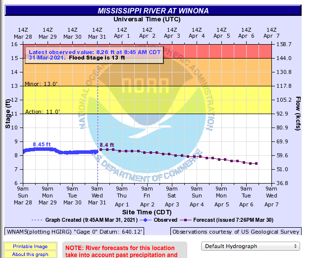
    I’m looking to spend a couple days this weekend in the Winona or maybe a little north with the Kayak on Mississippi backwaters.

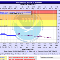
    I always struggle understanding current flow vs other times of the year. Getting gauge height as I think it is usually shown vs say a summer time normal or a year past when I was there and can compare.

    Like this reading of 8.4 ft – if it was 5 feet when I was there last fall, does that really mean the areas I fished are 3′ deeper now? I could be wrong on what it was last fall – so I want to see that as well.

    https://water.weather.gov/ahps2/hydrograph.php?gage=wnam5&wfo=arx

    Attachments:
    1. Screen-Shot-2021-03-31-at-10.16.51-AM.png

    Coletrain27
    Posts: 4789
    #2026310

    If you were reading 5’ on the same chart last fall then I would say yes it’s over 3’ higher now as long as it was the same chart

    JasonP
    Twin Cities
    Posts: 1360
    #2026368

    River hydrology is complicated. Here is my current understanding…

    1. Stage height only measures the river level at the gage. If you are fishing near the gage the water will be 3ft higher if the stage height is 3ft higher than the last time you fished there. The water level in other areas of the pool, particularly backwaters, may not be anywhere near 3′ higher. That is because the floodplain topography varies widely along the length of the pool.

    2. Stage height and flowrate are not linear. Look at the graph of pool 2 below where the gage is downtown St. Paul. Stage height is on the left, flow is on the right. If the stage height goes from 3ft to 4ft the flowrate increases from 3.4 to 16.6 kcfs (thousand cubic feet per second). That’s an increase in flow of almost 500% with just 1ft of height increase. However, if the stage height goes from 4ft to 5ft the flow only increases 30%… important for a kayaker!

    Hope this helps.

    JP

    Attachments:
    1. Capture-1.png

    Chuck Melcher
    SE Wisconsin, Racine County
    Posts: 1966
    #2026393

    Is there a way to go back and look at past info, say from a year back? Like to make sure what an average flow is in the summer or on a particular date?

    tight_lines
    SE Minnesota
    Posts: 104
    #2026405

    This used to be a link that you could look up past years etc. at Lake City.

    It appears to no longer be correct and is actually displaying level below coon rapids dam.

    If you follow the link and then click on Access to Water Resources link at the bottom you should be able to pull up Lake City. I have had limited success though using this new website. Curious if anyone knows a better link.

    https://rivergages.mvr.usace.army.mil/WaterControl/stationinfo2.cfm?sid=LKCM5&fid=LKCM5&dt=S

    JasonP
    Twin Cities
    Posts: 1360
    #2026407

    Is there a way to go back and look at past info, say from a year back? Like to make sure what an average flow is in the summer or on a particular date?

    The answer is almost always… yes but. -)

    Yes, but it looks like the historical data is maintained by the USGS. Go to this website and adjust the dates to see the data. For example here is the gage chart for a year ago today. The gage was reading 12ft… almost 4ft higher than this year.

    Attachments:
    1. Capture-2.png

    JasonP
    Twin Cities
    Posts: 1360
    #2026413

    Here is last year’s summer gage data. Looks like the average was about 7ft.

    Attachments:
    1. Capture-3.png

    Chuck Melcher
    SE Wisconsin, Racine County
    Posts: 1966
    #2026432

    OK…. I think I’ve got it…. thank you!

Viewing 8 posts - 1 through 8 (of 8 total)

You must be logged in to reply to this topic.