1031 AM CDT MON OCT 29 2012
FOR OPEN WATERS SHEBOYGAN WI TO PENTWATER MI SOUTH AND NEARSHORE
WATERS FROM NORTHERLY ISLAND IL TO GARY IN…
…GALE WARNING REMAINS IN EFFECT FROM 1 PM THIS AFTERNOON TO
4 AM CDT TUESDAY…
…STORM WARNING REMAINS IN EFFECT FROM 4 AM TO 4 PM CDT
TUESDAY…
…GALE WARNING REMAINS IN EFFECT FROM 4 PM TUESDAY TO 9 PM CDT
WEDNESDAY…
* WINDS…NORTH INCREASING TO 35 KT GALES THIS AFTERNOON AND TO 50
KT STORM FORCE WINDS TONIGHT.
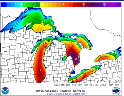
* SIGNIFICANT WAVES…8 TO 12 FT BUILDING TO 10 TO 14 FT TODAY…
TO 18 TO 23 FT TONIGHT…AND TO 20 TO 25 KT BY TUESDAY MORNING.
* OCCASIONAL WAVES…TO 19 FT THIS AFTERNOON…BUILDING TO 33 FT
BY TUESDAY MORNING.
PRECAUTIONARY/PREPAREDNESS ACTIONS…
A STORM WARNING MEANS WINDS OF 48 TO 63 KNOTS ARE IMMINENT OR
OCCURRING. RECREATIONAL BOATERS SHOULD REMAIN IN PORT…OR TAKE
SHELTER UNTIL WINDS AND WAVES SUBSIDE. COMMERCIAL VESSELS SHOULD
PREPARE FOR VERY STRONG WINDS AND DANGEROUS SEA CONDITIONS…AND
CONSIDER REMAINING IN PORT OR TAKING SHELTER IN PORT UNTIL WINDS
AND WAVES SUBSIDE.
A GALE WARNING MEANS WINDS OF 34 TO 47 KNOTS ARE IMMINENT OR
OCCURRING. OPERATING A VESSEL IN GALE CONDITIONS REQUIRES
EXPERIENCE AND PROPERLY EQUIPPED VESSELS. IT IS HIGHLY
RECOMMENDED THAT MARINERS WITHOUT THE PROPER EXPERIENCE SEEK
SAFE HARBOR PRIOR TO THE ONSET OF GALE CONDITIONS.
FOR WATERS BEYOND FIVE NAUTICAL MILES OF SHORE ON LAKE MICHIGAN .SYNOPSIS…A RIDGE OF HIGH PRESSURE AVERAGING 30.3 INCHES EXTENDS FROM THE TEXAS GULF COAST TO HUDSON BAY. MEANWHILE… HURRICANE SANDY WAS LOCATED OFF OF THE DELMARVA PENINSULA AT MID MORNING AT 28.3 INCHES. THE AXIS OF THE RIDGE WILL REMAIN NEARLY STATIONARY THROUGH MID WEEK. HURRICANE SANDY IS FORECAST TO MOVE INLAND OVER SOUTHERN NEW JERSEY THIS EVENING WITH A CENTRAL PRESSURE OF 28.0 INCHES. THE LOW WILL TRACK AS FAR WEST AS CENTRAL PENNSYLVANIA WEDNESDAY MORNING WHILE WEAKENING TO AROUND 29.1 INCHES BEFORE TURNING NORTH INTO SOUTHERN QUEBEC BY FRIDAY MORNING…WEAKENING FURTHER TO 29.3 INCHES. // WAVES ARE PROVIDED AS A RANGE OF SIGNIFICANT WAVE HEIGHTS…WHICH IS THE AVERAGE HEIGHT OF THE HIGHEST 1/3 OF THE WAVES…ALONG WITH THE AVERAGE HEIGHT OF THE HIGHEST 10 PERCENT OF THE WAVES WHICH WILL OCCASIONALLY BE ENCOUNTERED.
——————————————————————————–
This Afternoon: N wind 25 to 30 kt, with gusts as high as 40 kt. Partly sunny. Waves around 11 ft.
Tonight: N wind 35 to 40 kt, with gusts as high as 50 kt. Mostly cloudy. Waves 13 ft building to 17 ft.
Tuesday: N wind 35 to 40 kt, with gusts as high as 50 kt. Showers likely. Waves 20 to 22 ft.
Tuesday Night: NNW wind around 35 kt, with gusts as high as 45 kt. Showers likely. Waves 18 to 20 ft.
Wednesday: NNW wind 25 to 30 kt, with gusts as high as 40 kt. A chance of showers. Waves 17 ft subsiding to 13 ft.
Wednesday Night: NNW wind 20 to 25 kt, with gusts as high as 30 kt. A slight chance of showers. Waves 10 to 12 ft.
Thursday: NNW wind around 20 kt, with gusts as high as 25 kt. A slight chance of showers. Waves 7 to 9 ft.
Thursday Night: NNW wind around 20 kt. Partly cloudy. Waves 6 to 7 ft.
Friday: NNW wind 10 to 20 kt. Mostly sunny. Waves 5 to 6 ft.
Whats next?
Earthquakes in California & British Columbia with Tsunami Warnings on the Pacific from Alaska & Washington to Hawaii & Beyond. A Hurriacane Hitting New York & the East Coast with a major Cold bearing down and Gale Warning on the Great Lakes.
AP Reporting:
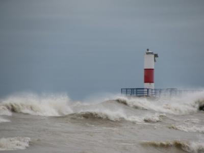
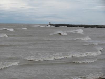
HOLLAND, Mich. — Severe weather bearing down on the Eastern Seaboard could lead to waves as high as 33 feet on parts of Lake Michigan and dangerous conditions on other Great Lakes.
The National Weather Service has issued Great Lakes gale and storm warnings in effect through Wednesday. It says waves on Lake Michigan could be 10 to 18 feet by Monday afternoon, then build to 20 to 33 feet on Tuesday before subsiding. Waves on parts of Lake Superior and Lake Huron could top 20 feet.
Dangerous conditions are expected along piers and breakwalls in areas including southwestern Michigan. Snow linked to the storm could fall in parts of Michigan.
Hurricane Sandy strengthened early Monday, putting it on a collision course with two other weather systems that would create a superstorm.
Makes me glad I live in Minnesota!