LotW Water Levels

  • Justin Donson
    Posts: 339
    #2123637

    Not the canadian side, but Arnesen’s posted a picture of their harbor the other day and the water is noticeably higher already than a lot of recent years.

    Steve Hix
    Dysart, Iowa
    Posts: 1131
    #2123765

    That is Helliars Resort. I will be there on the 29th.

    jagermeister
    NW Ontario
    Posts: 101
    #2123776

    Was on the lake in Morson yesterday ,lots of docks under or almost under water. Still lots of ice on the large parts and more rain on the way.

    slough
    Posts: 457
    #2123789

    Saw an article yesterday in the GF Herald that mentioned the lake was up 25 inches since melting began.

    Ike Sell
    Posts: 78
    #2127189

    That is Helliars Resort. I will be there on the 29th.

    I’ll be there on June 4-11 for my first visit to this area of LOTWs. Very interested in your experience. How did the high water levels affect the fishing, water temps, etc.

    Karry Kyllo
    Posts: 1141
    #2127195

    <div class=”d4p-bbt-quote-title”>Steve Hix wrote:</div>
    That is Helliars Resort. I will be there on the 29th.

    I’ll be there on June 4-11 for my first visit to this area of LOTWs. Very interested in your experience. How did the high water levels affect the fishing, water temps, etc.

    I was up there last weekend and fishing was good. Fish it like you normally do and you’ll catch fish.

    Steve Hix
    Dysart, Iowa
    Posts: 1131
    #2127202

    Massive storm today. Coming in got rained on by the buckets and lightning way too close.

    Attachments:
    1. P5280004.jpg

    Dutchboy
    Central Mn.
    Posts: 16023
    #2127225

    With Crane, Namakin, Kabetogama & Rainy Lake all flooding at near historic levels it’s no shock LOTW is flooding. It will get worse before getting better.

    Dutchboy
    Central Mn.
    Posts: 16023
    #2127362

    Raining again in International Falls right now. More water for LOTW.

    BigWerm
    SW Metro
    Posts: 10249
    #2127400

    The amount of water required to flood these huge bodies of water is incredible. I saw somewhere the amount of water flowing into Rainy during the huge rainstorms was the equivalent of 10 Lake Minnetonka’s per day. Crazy!

    CaptainMusky
    Posts: 19403
    #2127401

    The amount of water required to flood these huge bodies of water is incredible. I saw somewhere the amount of water flowing into Rainy during the huge rainstorms was the equivalent of 10 Lake Minnetonka’s per day. Crazy!

    Someone shared a map of the Rainy River watershed (ala LOW watershed) and it was enormous! Reaching well into Canada.

    Michael C. Winther
    Reedsburg, WI
    Posts: 1480
    #2127455

    just think…that entire watershed flows out through the Norman dam in Kenora.
    combine that with Lac Seul’s water from the English River…and those two combined still only make up 50% of Lake Winnipeg’s watershed. it’s a stunning amount even under normal conditions.

    CaptainMusky
    Posts: 19403
    #2127458

    I wondering how dang high the water is going to be when we get to Sioux Narrows on the 18th. I am sure that pier at the landing will be well under water. There was one year it was a like a 5 foot drop to the water.

    Jason
    Posts: 713
    #2127541

    I saw that Springsteel Island “just north of Warroad” was looking for a bunch of volunteers to help sandbag today. They have a site set up in town to fill bags and then they will haul them up to the point later today.

    CaptainMusky
    Posts: 19403
    #2127626

    I saw that Springsteel Island “just north of Warroad” was looking for a bunch of volunteers to help sandbag today. They have a site set up in town to fill bags and then they will haul them up to the point later today.

    That was the resort I saw the video on FB of with water surrounding the cabins. That was nuts.

    Steve Hix
    Dysart, Iowa
    Posts: 1131
    #2127891

    I’ll be there on June 4-11 for my first visit to this area of LOTWs. Very interested in your experience. How did the high water levels affect the fishing, water temps, etc.
    [/quote]

    The water is very high. Lots of northern in Stoney Bay. We had to go out to deeper water to find our walleyes. Most in 20 to 25 fow with deeper water nearby. Hope you have better weather.
    It has rained almost every day. Hard rain!! One day without rain, so the wind blew like hell.

    Good luck

    CaptainMusky
    Posts: 19403
    #2127939

    We’re worried our island will be under water for our trip starting June 18. Normal water years its maybe 3 feet above water level. Called the baitshop in Sioux Narrows yesterday and he said the government dock is already well underwater. With knee high rubber boots you would get wet he said. Only going up from there.

    CaptainMusky
    Posts: 19403
    #2128004

    A buddy just told me a DNR guy said LOW should have crested this week. That would be a heckuva surprise to me since the Rainy hasnt crested and they just got 4 more inches of rain.

    Loomis13
    NULL
    Posts: 109
    #2128074

    Musky, we heard the same thing about cresting this week. I also find that hard to believe. We are heading up Thursday, will definitely be an interesting trip. Hopefully they are right about the peak!

    supercat
    Eau Claire, WI
    Posts: 1243
    #2128094

    Here is what the government dock looked like may 20th and it way worse now. The water is still on the rise inflow is 70,000 and max outflow is 50,000

    https://www.lwcb.ca/pdf/LakeoftheWoods.pdf

    Attachments:
    1. IMG-20220520-WA0000.jpg

    fishinfreaks
    Rogers, MN
    Posts: 1130
    #2128143

    A buddy just told me a DNR guy said LOW should have crested this week. That would be a heckuva surprise to me since the Rainy hasnt crested and they just got 4 more inches of rain.

    DNR guy doesn’t know what he’s talking about. The Rainy watershed has to drain to LOTW. LOTW won’t see any relief or crest till July.

    Up in Morson now on Sabaskong Bay. First three days the SW wind blew that brought the lake up 10 inches where we are. So in addition to the almost record high water, you’ve got “tides” to deal with.

    Here is a photo from last fall and a couple from this spring. Notic the boat. It hasn’t moved. The water is up 5 feet. This shed usually sits 3 feel above the water. The dock was rebuilt in the high water of 2014, and it was 10 inches out of the water then. It’s nuts up here.

    Attachments:
    1. 20220602_105328-scaled.jpg

    2. 61276.jpeg

    3. 20220601_155834-scaled.jpg

    Dutchboy
    Central Mn.
    Posts: 16023
    #2128160

    Rainy has not reached it’s crest yet. It’s surpassed the 1950 record and is still rising. Lots of water headed to LOTW yet.

    Krh129
    Posts: 132
    #2128165

    I was fishing the last week about 30-40 miles north of Mine Centre which is west of Aitikokan on Hwy 11 and part of the Rainy Watershed. The area received about 4.5 inches of rain Monday-Thursday.

    Just a mess everywhere and it looks like a long event not over anytime soon around Rainy, hard to believe LOTW is going to crest anytime soon

    Michael C. Winther
    Reedsburg, WI
    Posts: 1480
    #2128279

    2022.06.03 Lake Level Forecasts
    by Secretariat June 3, 2022

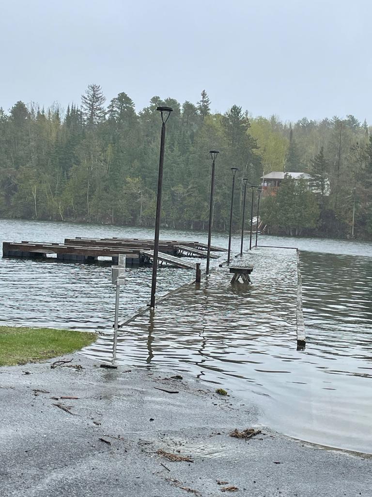
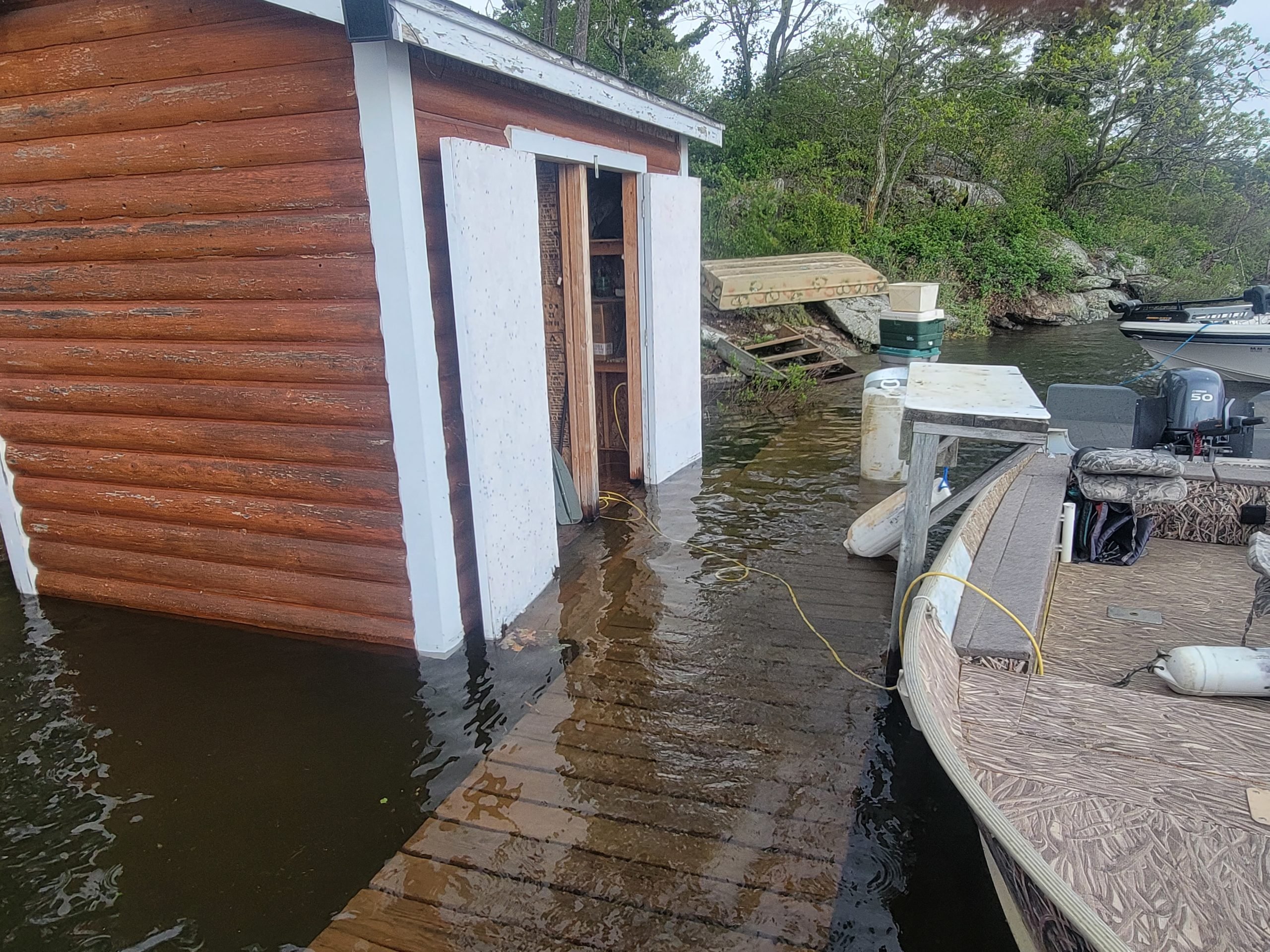
    The current level of Lake of the Woods is 323.93 m (1062.8 ft), over 95th percentile level for this time of year. The average lake level rose by 11 cm (4 in) over past week. The lake level has risen above the 2014 peak of 323.78 m (1062.29 ft) and is below the record peak since regulation began of 324.31 m (1064.0 ft), set in July of 1950. The dams in Kenora remain fully open and no additional actions can be taken to limit lake level rise.

    The level of Lake of the Woods is expected to rise by approximately 3-6 cm (1-2 in) over the next 7 days, the rate depending on the rainfall received across the region. Should weather be favourable, a peak may be reached by mid-June followed by a gradual drop. However, a return to normal summer levels will likely take many weeks, and will be delayed should there be a return to wet weather.

    CaptainMusky
    Posts: 19403
    #2128284

    The dock was rebuilt in the high water of 2014, and it was 10 inches out of the water then. It’s nuts up here.

    That is crazy so it has to be over a foot higher than 2014 then. Sheesh. THat is wild. Hopefully no significant rains. Its crazy to think last summer we were in a severe drought.

    CaptainMusky
    Posts: 19403
    #2128354

    Here is what the government dock looked like may 20th and it way worse now. The water is still on the rise inflow is 70,000 and max outflow is 50,000

    Was this photo taken by you? Curious if there was any flooding on the road to Sioux Narrows. It was flooded in sections back in 2014, but I think they did some improvements since then.

Viewing 30 posts - 1 through 30 (of 36 total)

You must be logged in to reply to this topic.