CMAP Confusion

  • Finnish Minnow
    Wisconsin
    Posts: 23
    #1780733

    Hello,

    Brand new to this site. I did some searching and if this was addressed and I missed it, my apologies.

    I purchased CMAP Lake Insight HD (Max-N+ Central North Region). There were no instructions in the box, and I checked various “CMAP” sites in an attempt to register the software. Not sure how the community function works. I see Genesis and other terms linked to CMAP and I am wondering if these are old terms, if there was a company change and Lake Insight is different than Genesis or what.

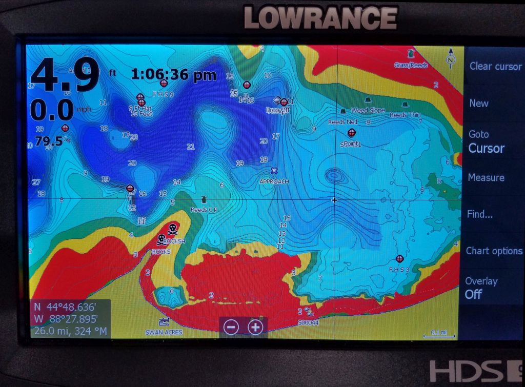
    I spent a few hours searching the web and found some videos on how to do the custom shading on my Lowrance Carbon only to find out the lake I was trying to do this on is, apparently, not supported by CMAP. That said, I couldn’t find a website that lists what lakes are covered by CMAP. I received a recommendation from a friend and for Green Bay, Sturgeon Bay, and the Lake Michigan shoreline, the CMAP chart is excellent, but Shawano Lake, a 6000 acre lake in Wisconsin, does not appear to be included.

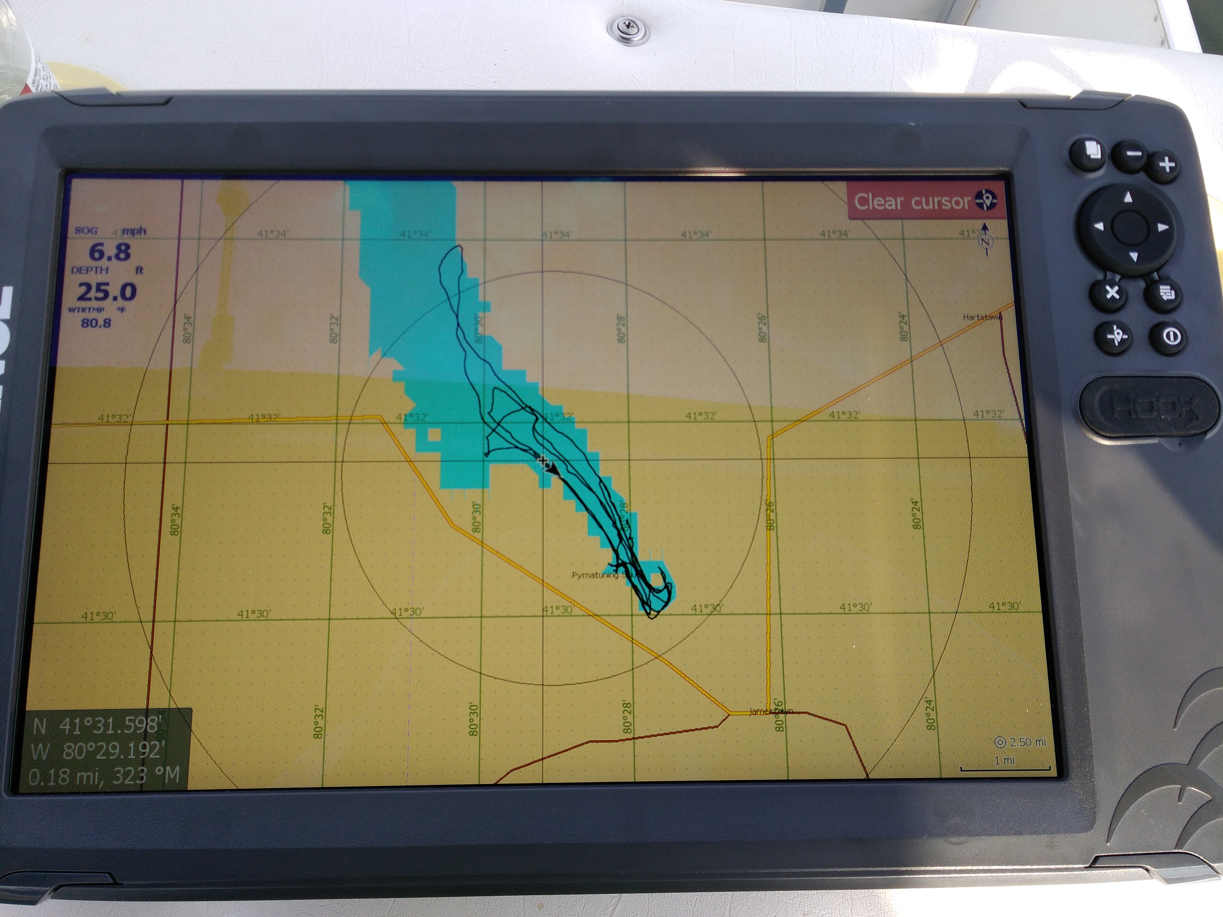
    Suggestions on using the sonar mapping function and how to share the data that other users send in? Or do I have the wrong card?

    I am very used to Navionics and Lake Master. The new Navionics Card hasn’t come in yet. I have an older Navionics, but it is standard SD size, which will not work in the Carbon units. I think I will be trading for some upgrades with Navionics.

    Any thoughts or links would be appreciated.

    Thanks!

    Finnish Minnow
    Wisconsin
    Posts: 23
    #1782041

    Well, I have received no responses. I have spent the time since the post reviewing various websites and youtube. There is a lot of information out there; and it has not been easy to decipher.

    As for the social maps, when going to the website and viewing the maps, they look pretty awesome. Downloading them and getting them onto the unit was an interesting experience.

    Downloading and extracting the social map to the SD card plugged into the PC was pretty easy. However, I was only able to upload ONE map to my Carbon. Also it does not allow me to select the lake on Chart Options, where I choose Lowrance, CMAP, or Navionics.

    Back to the web, learned about the GOFREE store and accessed it through the Carbon using WIFI. Downloaded two maps, and both work well and show up on Chart Options along with Lowrance, CMAP, and Navionics. Problem is I cannot load more than two maps.

    Received the latest and greatest from Navionics this week. I do not care for their shading options. I am so used to be able to set custom shading on my old Humminbird with Lakemaster. I use red for the shallow areas that are waiting to eat my prop or lower unit, transition to yellow, then green, and lighter shades of blue to dark blue for the deepest water. After doing that for several years, those colors are in my head. Navionics gives me some red dots for the shallow area and then shades of blue or white. Oh well. With CMAP, I can attain the same shading as with Lakemaster and with more precision. Problem is, the shading does not work with all of the maps loaded on their card, though it works fine on the social maps.

    I have sent an e-mail to customer service for CMAP with my questions. I will share the responses if anybody is interested. Until then, any suggestions people have for me will be much appreciated.

    I heard Garmin bought Navionics. Not sure what that means for the future.

    catnip
    south metro
    Posts: 621
    #1782120

    Man that sucks! Can you make your own maps while on that lake?

    Finnish Minnow
    Wisconsin
    Posts: 23
    #1782127

    Yes, I can make my own maps with either the Lowrance Sonar Recording function, which uses CMAP/Genesis or the Navionics function, Sonar Chart Live.

    Haven’t tried it yet, so I will have to see what it looks like. Using Navionics, the new contours will show up immediately, but using the Lowrance/CMAP recording, I don’t believe anything shows up live.

    My experience was with Autochart from Humminbird. Spent about 5 hours recording an uncharted lake and then about as much time generating the map on the PC. It was a bit cumbersome, learning how to get rid of errors and things that appeared quite goofy. I am sure with experience, I would get faster.

    I used the Humminbird PC program pretty regularly, but that is gone now.

    CaptainMusky
    Posts: 19219
    #1782268

    I have the Navionics Plus map chip that was downloaded the freshest data and last week I used SonarCharts Live for the first time.
    WHOA! Its incredible!
    It presents itself as an additional overlay that you can turn on or off. When on its recording and displaying. When I would run from spot to spot I would turn it off and then back on to scope out new spots and record/update the chart.
    I was in an area of LOW that is void of detailed high definition maps. When I downloaded the freshest data to the Navionics chip, the area had 1 foot contour lines where previously there were only hazards marked. Now I have detailed AND accurate HD maps of the areas we fish up there. Super Sweet!
    It happens so fast that you cannot even believe it is doing anything.
    This is really going to improve things going forward with how easy these live mapping tools are now.
    I too used the record sonar/Upload file to Lowrance Community and download. Putzy and painful. This is so much easier!

    Finnish Minnow
    Wisconsin
    Posts: 23
    #1782296

    Thanks, Captain.

    From what I have read/watched, it seems the Navionics Sonar Chart is much easier to activate and use compared to CMAP.

    Do you know of any way to shade with Navionics to get something like this?

    Attachments:
    1. Shawano.jpg

    CaptainMusky
    Posts: 19219
    #1782339

    So far I have only shaded the shallow water to blue. I am not sure if you can use multiple colors like shown there. I haven’t played with it much. I know the chip automatically changes colors as depth changes, but you can set a specific depth to a certain color. I set water < 6′ to be dark blue for safety reasons. I will try and play around with it more. I believe you can choose which color you want as well, but I didn’t play that close attention when I set it up.

    CaptainMusky
    Posts: 19219
    #1782340

    I had a good chuckle the one night in the tent trying to fall asleep with 2 snoring guys in my tent and then outside I had 2 loud mouth drunks “solving the world’s problems”. They were talking about all the electronics stuff I have setup in my boat, SonarChart Live, side/downscan, etc. They said that those things take the fun out of it.
    Considering they have never seen any of it in action or used any of it I just chuckled.
    They are tools like anything else. When I find fish and have success I want to know why. Why are the fish there? Are there other spots similar? By using these tools I can then locate other spots and form a pattern. Those guys just fish the same spots over and over again and wonder why they struggle.
    Many times I will drive around a spot to check it out before even wetting a line. No sense in dropping a line if there are no fish.

    Finnish Minnow
    Wisconsin
    Posts: 23
    #1782351

    Funny. I have had people who don’t fish often–or maybe well–say the same thing. Even if you find them, you still have to catch them!

    Dr. Pomoxis
    Posts: 55
    #1783643

    Fred, I bought CMAP Lake Insight last year, and have been really frustrated with it as well. The lake I fish is awful, in my opinion. I spent hours mapping and uploading, and it doesn’t seem to have helped the problem, when i download the social map. I came on tonight to see what people think of Navionics for Lowrance. I have the app on my phone, which is OK, but wondering how much better it would be for Pokegama lake in Grand Rapids MN than Genesis/CMAP.

    Finnish Minnow
    Wisconsin
    Posts: 23
    #1783657

    Hey Doc,

    This is what I have learned thus far:

    1 – CMAP customer service is slow. Haven’t heard back from them yet.

    2 – You can download 1 map (5 files) per SD card and use it on the Carbon. I have downloaded several maps, but only one will work, I cannot switch to another.

    3 – You can transfer the five files for a map onto the CMAP card itself, thus giving you the capacity of two maps on on Carbon unit. I am able to do 3, as I have another Carbon at the bow linked to the helm.

    4 – The custom shading only works on some of the lakes that came with the CMAP card, but it has worked on every social map I downloaded.

    5 – For now, I am using CMAP simply for moving around to avoid hazards (I know, I am trusting the chart data) by use of the custom shading. When I start fishing, I switch it to Navionics.

    6 – I really do like Sonarchart Live with the Navionics card and the Carbon. I haven’t uploaded the data yet, as I want to make sure my data stays right where it is on my chartplotter — I don’t want to have my recorded data disappear and then be “averaged” in with the other uploaded data and get that data in my upload. Still learning.

    7 – The first GPS I used on a boat was a handheld Magellan unit and this was before the selective availability was discontinued. I am amazed at the improvements. WAAS is wonderful. My first solid mount GPS on a boat was a Garmin 462 (I think) that I bought in 2003. Grayscale and the memory was so limited I could only add a few regions of my state and had to use a serial port connector to do this. The SD cards are great, but I much prefer the full size SD card. I have dropped the micro SD cards too many times already.

    Can you view the lake you mentioned on the website for Navionics? If not, I can take a look on my unit, but I will have to figure out if I can make a screen shot or just take a picture.

    Mark Williamson
    Posts: 1
    #1865994

    I share your frustration with these products. I’m a newbie to the fishfinder world, and did a lot of research to try and find out what charts came with the units. Lowrance provided C-Map with the Hook2 12″ fishfinder, and said it covered 3,000 or 4,000 or 5,000 lakes (depending on which ads you read) with 1 foot depth contours. I don’t fish (yet), so the GPS chart was what I most needed. Well, on the lake where my boat is permanently based, the standard app shows 8′, 18′ and 28′ contours when set to full detail. The support people responded that if that was what it showed, that’s as good as it gets. SO I invested in a Navionics+ chip for the USA Coast and Lakes, after exploring the online Navionics viewer and seeing the detail available. Ship arrived, plugged in, gave me the option to use it, shows very rough outline of lake with NO depth contours. So I went to the website, figured out how to register, how to update chip, etc., but no change. At this point, I’ve bought a 12″ fishfinder, paid to have it installed, bought a Navionics chip, and have nothing that’s remotely usable. So, I’m using my cell phone with a cheap boating app. To me, the whole Lowrance experience seems awful.

    Attachments:
    1. IMG_20190628_192621.jpg

    Calvin Svihel
    Moderator
    Northwest Metro, MN
    Posts: 3862
    #1866012

    Have you tried calling lowrance? They are super helpful when stuck on something either on the lake or in the garage pressing buttons.

    Lowrance Customer service 800-324-1356…they are closed for the holiday now, but give them a call next week.

    Finnish Minnow
    Wisconsin
    Posts: 23
    #1884455

    Calvin,

    It has been awhile since I tried calling anyone. I hear Lowrance now owns CMAP.

    Thank you for your reply and my apologies in the delay in responding!

    Fred

    Steve Zamzow
    Des Moines, Iowa
    Posts: 81
    #1884552

    I have been using Insight Genesis and CMap for a couple of years now. It takes some getting used to but you can put multiple maps on a single chip. Keep in mind the social maps are recordings so it shows lake levels at the time the recording was made. I use it alot and it has served me well.

    Finnish Minnow
    Wisconsin
    Posts: 23
    #1884612

    Steve,

    If you have a step-by-step instruction or a link to a website that has these instructions, I would really appreciate it!

    I was able to put of the social maps on my card, but the Lowrance Carbon (will all current software updates) only recognizes one.

    The file names all seem to be the same (see attachment). I have tried loading the files on the card having each under a file name for the lake, but it didn’t work.

    I also did download some social maps directly to my device through the device’s wifi connection and my CMAP account, but it would only do one at a time.

    I really would like to learn how you managed to get this to work, multiple lake files on the same card, each accessible by the device.

    What I have done is used multiple SD cards, which is a pain, as these files are not very large.

    Thanks!

    Attachments:
    1. CMAP-1.jpg

    2. CMAP.jpg

    Cody Meyers
    Posts: 388
    #1900870

    I’m going to bump this one up. I just got the same chip that the OP had questions about.

    My question: do you need to download the lakes you want to fish and all other lakes are either not mapped or set at default 3’ contours?

    For example, I was looking at Lake Waconia and when zoomed out (HD Bathymetry on) the lake appears in similar detail compared to my Navionics map. But when I zoom in it seems like I lose definition on the map and I only have 3’ contours.

    Is this a setting on the chip, or is this consistent with what others have seen?

    Is it just me or do the mapping options for hummingbirds seem much more straightforward? I’m pretty frustrated with Lowrance at the moment.

    Jesse Waldron
    Posts: 1
    #1913812

    Super disappointed in CMAP. Ready to throw the chip in the lake.

    No support, no instructions, maps are very poor at best. Extremely difficult to try to even figure out.

    Would not recommend C-MAP to anyone.

    Finnish Minnow
    Wisconsin
    Posts: 23
    #1948896

    I never did hear back from CMAP. Oh well.

    Cody Meyers
    Posts: 388
    #1948970

    Trash, I don’t really have any reason to by Lowrance products again.

    Finnish Minnow
    Wisconsin
    Posts: 23
    #1949708

    SOCIAL MAP SOLUTION for LOWRANCE

    Whytie posted a solution to this issue back in 2017. I found it last night. It is specific to Lowrance Units using social maps. I just did it this morning and it works!

    Uploading Insight Genesis social map to my chartplotter

    mplspug
    Palmetto, Florida
    Posts: 25025
    #1949992

    Can you tell me how this works, I have recorder or uploaded maps yet.

    Say you map a lake across several days. Will Genesis merge them all into one map to download?

    Finnish Minnow
    Wisconsin
    Posts: 23
    #1950441

    Genesis Live will actively map out the water, live and in real time when you are on the water. You set it as an overlay in Lowrance. You may need a CMAP card to use it, but I am not sure, since I have a CMAP card.

    If you don’t have Genesis Live, you record your sonar while on the water and then upload it.

    Genesis, CMAP, or whoever it is will then add your data to the Social Maps, which you can download.

    Here is how it works:
    https://www.genesismaps.com/HowItWorks

    Create and Account. It is free:
    https://www.genesismaps.com/

    Go to this site to find and download the social maps:
    https://www.genesismaps.com/SocialMap

    Good luck!

    Fred

    mplspug
    Palmetto, Florida
    Posts: 25025
    #1950796

    Thanks. I did look it up and it looks like you can manage the maps by merging multiple recordings and then download.

    My unit came with a base cmap and let’s you use Genesis live to map.

    mplspug
    Palmetto, Florida
    Posts: 25025
    #1953339

    I uploaded my first map and it processed. It is not showing up on the social map, but I read that it only gets updated at the end of the month? My files don’t show up under My Trips, do I need the edge account for that? I am not paying $100/yr or $25 a month for my flats data, although once I have enough uploaded I may sign up for a month to get my maps.

    So on the free account I assume I can’t merge or do anything, I just have to wait to see if it shows up on the social map and download it?

    mplspug
    Palmetto, Florida
    Posts: 25025
    #1953346

    I got a quick response from C-Map.

    Hi Michael,

    Yes, trips can take between a few days to a few weeks to get added to Social Map. Edge gives you access to your trips and the ability to merge your trips right away after they’re processed. Let me know if you have further questions.

    Thank you,

    -Ian

    Looks like I need to be patient. Then I can see if I can do anything with my maps besides downloading them in the Social Maps.

    mplspug
    Palmetto, Florida
    Posts: 25025
    #1958626

    Still waiting and it’s been almost a month. At this point I assume their “QA” process has rejected my map and since it’s not added to the community map, I can’t even access my own map I created. The interface is crappy, you can’t even see where your uploads are in progress.

    I may end up subscribing for a month in the future when I have enough data collected and have it processed so I can download it.

    Genesis mapping is going to probably prove to be useless in a kayak fishing mostly the flats. I don’t even know if it will work when I fish bridges, reefs and deeper water.

Viewing 28 posts - 1 through 28 (of 28 total)

You must be logged in to reply to this topic.