Uploading Insight Genesis social map to my chartplotter

  • Brian Robinson
    central Neb
    Posts: 3914
    #1693379

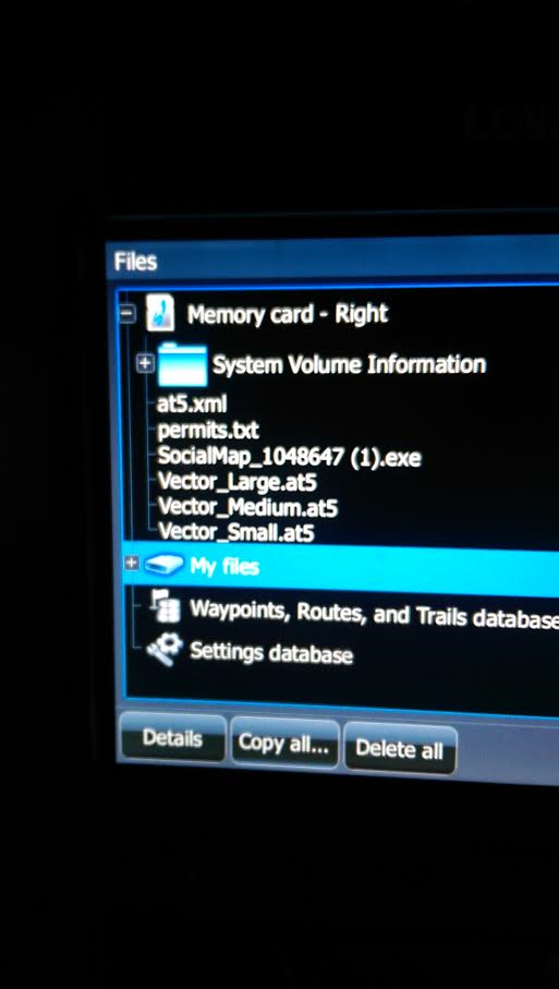
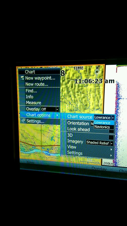
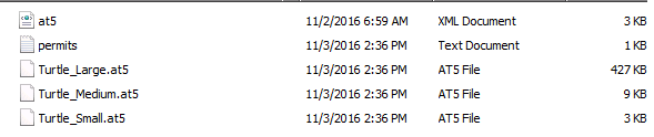
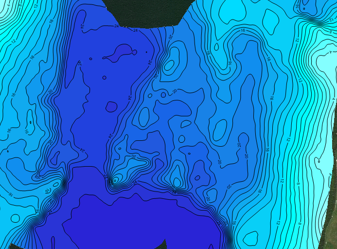
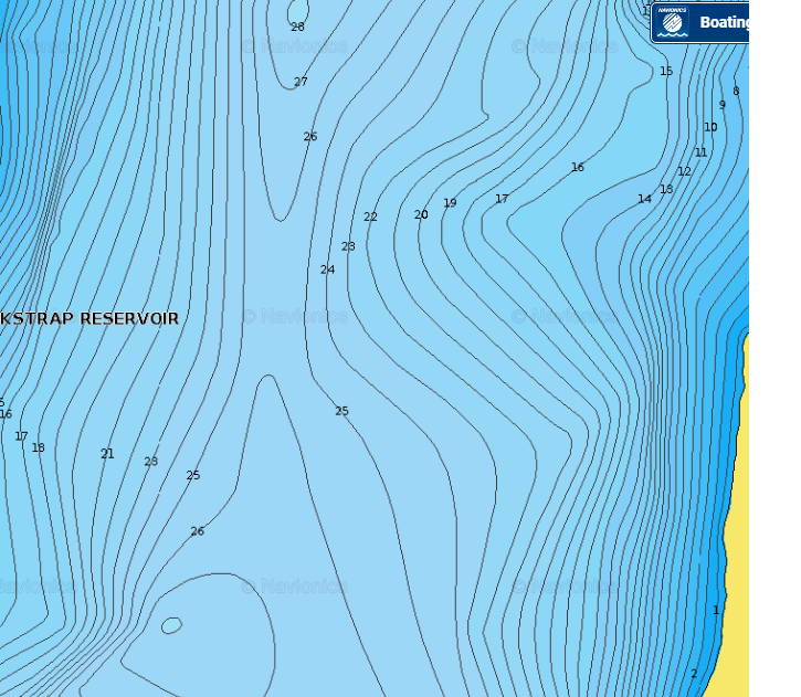
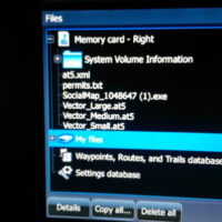
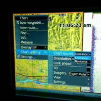
    I’m at the end of my rope here. I’ve been using my HDS 8 and 7 to map lakes for a couple years now, love doing it. Love adding to the social map, it’s a nice tool. But now I’m trying to get the social map onto my chartplotter, and no matter what I do, it will not work. I have downloaded the social map onto my laptop, then extracted the files to the SD card. I have loaded the map onto the SD card, then extracted. Nothing works. I put the card in the unit, it says loading charts, but when I go to my map options, nothing is available. In the picture, you can see all I have available are Navionics and Lowrance charts. My unit is registered on gofreemarine. Do I have to rename the files for them to show up? What am I doing wrong? Am I not going to the right place to bring em up? I know it’s gotta be something simple I haven’t got figured out yet. Any instructions would be great. My buddy is having no problem with his HDS 7 touch Gen 2, but my HDS8 Gen 2 will do nothing for me. Maps sure would be helpful. Thanks

    Attachments:
    1. lowrance-files.png

    2. lowrance.png

    whytie
    Saskatoon, Saskatchewan
    Posts: 106
    #1693418

    I had issues with my elite. Turned out the serial I used from the box didn’t match what was listed in my plotter. I fixed this by going to my account and updating the serial number. Also make sure you have the most up to date version loaded on your plotter I know a few guys who had issues in the past by not updating their units. And I’m sure you already know to insert the card before turning on the unit.

    Brian Robinson
    central Neb
    Posts: 3914
    #1693478

    I will make sure of those things. I know I’m updated, but I’ll check the serial and all that just to make sure. Surely it’ll be something else, but it’d be great if it were something that easy.

    Brian Robinson
    central Neb
    Posts: 3914
    #1693483

    Ok, checked the serial and other ID numbers, they are legit.

    Am I going about it wrong on the Insight site? I’m going to the social map, putting the lake I want on a card, like they say, then extracting files, then putting it in my plotter, and I’m getting no results. Very frustrating.

    Tim Bossert
    Cochrane, WI
    Posts: 429
    #1693681

    Please keep updating us. I am starting to venture into the map making myself, and hope to learn here.

    watisituya
    North Metro
    Posts: 238
    #1693713

    Have you tried just downloading the Lake map directly onto your unit via wifi? I didnt have access to a computer the other day and ended up doing that but fyi you can only download 1 lake to a card this way, otherwise it tells you to insert a card with more space. Not an answer to your problem but maybe a temp fix to get your data out on the water this weekend?

    whytie
    Saskatoon, Saskatchewan
    Posts: 106
    #1693724

    what size of and SD card are you using? I believe 32gb is the max size that can be used.

    whytie
    Saskatoon, Saskatchewan
    Posts: 106
    #1693726

    Actually I just spotted the problem toast . Get rid of the “social map.exe” file you only need the 3 contour contour files(.AT5), the permit file(.TXT) and at5 file(.XML).(5 files in total)

    You can add multiple lakes by placing them in individual folders on the SD card and renaming the lake contours to (lakename)_large.at5. Just make sure you have both the permit and AT5 file in the folder as well.

    Brian Robinson
    central Neb
    Posts: 3914
    #1693755

    Actually, my problem may not be on here, at least I hope. I talked with Lowrance today; was impressed by how quick I got in, and how helpful he was. I’ve done all the basics, made sure of this and that….except one thing. The serial and content ID numbers are case sensitive. One is alphanumeric. So, I checked on my numbers- sure enough, the letters were lower case when they need to be upper. So I changed that, and will give it a try.

    He also told me there will be 5 files, and I believe he said you need em all. I will look into that too.

    Ryan P
    Farmington
    Posts: 223
    #1693845

    You can add multiple lakes by placing them in individual folders on the SD card and renaming the lake contours to (lakename)_large.at5. Just make sure you have both the permit and AT5 file in the folder as well.

    I tried this and was not successful but then gave up cause I still have time left on my Navionics subscription. I was going to test and see if it is a viable solution instead of paying $100/year. I could get 1 map to work but never multiples.

    whytie
    Saskatoon, Saskatchewan
    Posts: 106
    #1693868

    Ryan make sure when you add multiple files to change the names on the contour .AT5 files and keep the permit and AT5.xml files all together in one folder.

    one thing to mention is to keep the AT5.xml and permit.txt with their correct contour files. They maybe labeled the same but the internal coding is different.

    Also be sure your plotter is up to date. these are all things I’ve learnt when struggling with my own.

    Here’s and example of my folder structure in my SD card.

    Attachments:
    1. blackstrap-file-structure-1.png

    2. blackstrap-files-1.png

    3. turtle-files-1.png

    4. blackstrap-file-structure.png

    5. blackstrap-files.png

    6. turtle-files.png

    whytie
    Saskatoon, Saskatchewan
    Posts: 106
    #1693881

    The navionics cards for Saskatchewan are pretty poor. I rely heavily on mapping software to build my own maps here’s and example of Blackstrap lake.

    Attachments:
    1. blackstrap-insight.png

    2. blackstrap-navionic.png

    Ryan P
    Farmington
    Posts: 223
    #1693886

    Thats awesome! Thanks for the info! I will give it a shot this weekend and see how it works.

    Brian Robinson
    central Neb
    Posts: 3914
    #1694262

    I called Lowrance again and she told me about the file folders, which nobody had mentioned before to me. Once I created new files for lakes, I put the files in there, and sure enough, the lake I was fishing popped up.
    Now, as stated above, it only gave me the choice to chose one lake, and I put two on the card. So, I will try it again and see if it’ll work, but so far, it’s only letting me do one lake.

    TripleA
    Blaine
    Posts: 655
    #1694280

    Ive only ever been able to get one lake to work at a time, and only 1 map as well either vegetation, composition, or contours…..

    Brian Robinson
    central Neb
    Posts: 3914
    #1694461

    Lady at Lowrance made it sound like if you make folders for each lake, you can put as many as you want on one card. So, I hope to figure that out next without calling them back.

    Ryan P
    Farmington
    Posts: 223
    #1694472

    From what I understood you have to choose when you start the unit which folder to access. I have set up the card as suggested by whytie but can’t test it cause my boat is currently getting the transom replaced. When I get it back I’ll try it out and see what happens.

    John Shear
    Chippewa Falls, WI
    Posts: 205
    #1697026

    I have maps for several lakes on my laptop. There is a directory for each lake and each directory contains the 5 files. I don’t rename any of the 5 files. I can copy multiple directories to the SD card, so each lake is it’s own directory.
    When I turn on the sonar unit, it chooses one name and asks if I want to load that. If it’s not the one I want, just select whatever is highlighted (YES or NO, it doesn’t matter). Then go in
    Menu -> Chart options -> Chart source and it lists all the lakes to select from.
    This is on Gen2.

    John S.

    Brian Robinson
    central Neb
    Posts: 3914
    #1697433

    I’m still not getting that option to choose other lakes on my card, just the one that comes up. I’m going to work on it when I get my computer back, which is currently getting an overhaul. Have talked to Lowrance a few times, and I hope what they’re telling me will work.

    John Shear
    Chippewa Falls, WI
    Posts: 205
    #1698283

    I talked to a friend who just got Gen3 units and is starting to use GoFree maps. He said if he has 5 lakes on the SD Card, when he turns the unit on, it asks “do you want to use lake xxx” 5 times. So he has to answer the question for every lake on the card which is really annoying for him.

    Finnish Minnow
    Wisconsin
    Posts: 23
    #1949706

    THANK YOU THANK YOU THANK YOU

    I gave up on trying to get this to work over a year ago. I was stuck with one chart visible only. My search on this site didn’t find this thread, but it is on me. I posted a thread with questions and there were others who were wondering to…at least in response to my post. I am going to link this to my thread from quite a while back!

Viewing 21 posts - 1 through 21 (of 21 total)

You must be logged in to reply to this topic.