Forum Replies Created

Viewing 20 posts - 1 through 20 (of 20 total)
  • Dan Halicki
    Posts: 26
    #1780472

    Just as a follow up in case someone searches this in the future. I did purchase the GT 30 12-pin ducer to run as a portable unit, all functions seem fine on it for mapping and navigation, however the standard sonar function does not show up as an option. Just navigation, DI and SI.

    Dan Halicki
    Posts: 26
    #1770037

    I only ask here cuz this is a fresh thread and I searched and found mixed results and don’t feel it requires a brand new thread.
    I know years ago if fishing the MN-WI waters of Miss you could have 12 total possession over 2 days (6ea day) if fishing on our Wisconsin license, now the DNR site shows 6 total. So I’m assuming it’s now same as MN regulations and a total of 6 possession total even over 2 days correct?

    Dan Halicki
    Posts: 26
    #1765805

    Thanks guys. I believe you are correct catnip, but I won’t be spending $300 for a transducer for this, ha.

    Henpecked, thanks for that. In there it lists the ducers that will coordinate with Quickdraw and lists “any Chirp enabled, clearvue Garmin ducer” and looking at their transducers they have a FT21-TM that shows both of those, however my stock ducer is 12-pin and that one lists at 8-pin so I’m assuming that won’t work, even though I have it set to only show me compatible transducers with my model.

    Dan Halicki
    Posts: 26
    #1712658

    Thanks for the replies guys. I have this all straightened out now and figured I’d update on here since someone else can easily have the same issue. After reading multiple places I kept reading “any over the counter SD card max size 32gb will function properly. After going to my 7 year old 8gb that worked I looked why my new 32 wouldn’t. From what I understand any class 4-10 card will work, however it cannot be the newer UHS-11/UHS3 cards, it must be 4-10 class however only standard/UHS1 cards. Not only is this why my update did not complete, it’s also why my contour creation would not work, it would show green circle but no recording, also didn’t state anything about failure with card.

    Even Garmin support didn’t mention this after 40min on phone, I’m also going to update them that if someone calls with similar issue, before telling them to warranty swap a new unit, find out which card they’re running, because of they bought a nice newer fast card for their new unit, it will not work.

    That all being said, I messed with just contour creation today for about 4hrs and I must say it is incredible. I’ll post a pic of my work (the standard included contour map wasn’t even close) but I did have a question, is there way to set it so when recording it will indicate the color contour also? Right now it just shows all green while driving until I turn recording off and back to navigation screen. (while fishing I’d like to vertical jig an area while recording but would like to see the color contour if possible)

    Thanks
    Dan

    Attachments:
    1. IMAG1387.jpg

    Dan Halicki
    Posts: 26
    #1712487

    It’s the conversion of them that I just can’t find a process on how to do.

    Dan Halicki
    Posts: 26
    #1712266

    I received replacement unit (other one replaced due to an issue with the Quickdraw) today so I decided to try the update again before testing on water this week. Again, same result. For the hell of it I decided to pull an SD card out of a 7 year old phone and try that, even tho the other 2 I was using are brand new Transcend Ultimate 633x cards and supposed to be excellent cards. Well, the update completed as it should so I am now on software 4.1

    Another question, I am trying to research this the best I can but I found the process of how to pull waypoints ect into this Garmin through the menus, but I can not find anywhere as to how to properly convert the files from my Humminbird 688ci. I am set up on the Garmin Express and thought maybe there would be something on there but I found nothing. Older threads are mentioning using the Humminbird PC program but I cant locate that anywhere.

    Thanks
    Dan

    Dan Halicki
    Posts: 26
    #1711905

    Pat-maybe I’m missing it but where does it say depth source unknown? I didn’t suspect a sonar issue because the standard sonar, down and side imaging seemed to be working normally. I’m sure sensitivity is off cuz it literally didn’t stop marking 40 fish at a time but it seemed to function normally. Also I did check to make sure it’s compatible.

    Trent- I’m glad you noted that, I was sure since the update is so recent that the 3.8 units might have gotten some tweaks but I assumed it still worked.

    I talked with customer support while out there for about an hour. Tho very friendly, unfortunately not much additional info other than what I was able to try myself. He noted its likely a defective unit it. I have a 30 day exchange policy through where I bought it so I’m going to get new one, swap head units and give it another whirl. I hope I can straighten all this out, I was really excited about the Quickdraw for our trip in 2 weeks to non mapped Canadian waters.

    Dan Halicki
    Posts: 26
    #1711456

    Thanks for the replies guys. I did follow that process exactly. I opened the file that downloaded, a Garmin prompt came up and had me select which file to extract to, I chose the SD slot and it loaded. I verified there was a Garmin file on the SD but didn’t see which it was. I will check that after work and if it’s the correct one I will give customer support a call the next time I am at the boat with the system and laptop.

    Dan Halicki
    Posts: 26
    #1710414

    Thank you for the reply.

    Regarding the system update, I did exactly that. I followed them straight from the Garmin website. I inserted after unit was turned on, screen prompt came up for software update, I followed the prompts through and it looked like everything was going to plan. However it went very quickly and did not update. As the progress bar was showing as if it was loading it kept giving me the prompts that it was doing what I listed in the above message, then would reboot normally and show still as old software.

    For the waypoint transfer I did some research on that also and was able to find the location where it has the option to merge the waypoints so I selected that and it said none found on SD card. There is also a prompt on that screen that allows a format change, there are 2 options, I did try both and neither way did it find any waypoints.

    Dan Halicki
    Posts: 26
    #1710401

    So I received the unit and was able to get it all installed last night. Today I decided to transfer my way points over from my Hummingbird 688 and also update the unit. I followed directions to load update onto SD card and loaded into my humminbird and loaded on the way points. I drove over to the boat and first tried the update. The whole process was about 20 seconds long after selecting to update. This was what it read all 3 times I tried, update never happened.
    Scanning
    Initializing region transfer
    Scanning card
    Region transfer complete
    Preparing to reset the network.
    Restarts normally and no update. Takes total of about 20 seconds.

    Also, it doesn’t locate any files on SD card for the way points from Hummingbird. Am I just doing everything wrong here?

    Dan Halicki
    Posts: 26
    #1709127

    I’ll definitely give that a try, thanks.

    Unit is Garmin 010-01802-01 Echomap Chirp 73SV with transducer

    Dan Halicki
    Posts: 26
    #1709099

    Excellent, thanks for the tips.

    This is likely a dumb question, but I am trying to register it thru Garmin website and its asking me to connect to my PC. If I am not mistaken, there is no way for me to connect it to PC other than through the SD card correct? I would love to be able to at least fire it up and mess with it some but I am not near my boat right now and it’ll be a bit until I can wire it in. There isnt some random way to get it fired up to tinker with settings ect without the actual boat wiring is there?

    Dan Halicki
    Posts: 26
    #1709067

    More great info, thanks. I just received my Garmin today in the mail and quite excited to get it set up. My motor is still in the shop so it might be a bit until I get it out but I want to get it updated ect. Also, have you heard how easy/difficult it is to copy over Way points ect from a Humminbird unit? Unfortunately the boat is stored at my brothers about 20min away or so, so I can’t just go out and get it hooked up. If only there was an easy way to power these units up away from the boat/base/battery.

    Another thing that drove me nuts is we didn’t install the transducer low enough for my current unit so I’d lose all sonar anytime I went over 5mph. I’m a little nervous mounting slightly below bottom of boat with all the rock shores ect we pull up on in Canada for shorelunch ect, but I’ll just have to be very cautious.

    Dan Halicki
    Posts: 26
    #1708514

    Thanks again for the info. I do believe I will be ordering the Garmin unit this week. I should have motor back in next 2 weeks and will get it out and mess with it before Canada next month.

    I really like what you guys are stating as far as leaving it on while fishing to cover an area more exact, and also that you can create the contours at a pretty decent speed, I had a feeling it was going to be a much slower process.

    Do you guys know which transducer you have with yours (the guys running factory ducer it came with)? The one I am looking to grab has a good price of $652 shipped and it states it comes with the newest ducer model 010-01802-01

    The scrolling back to mark a GPS waypoint from sonar screen is something I am really looking forward to. Some of these pockets of aggressive walleye I will stroll through while exploring a spot I can never seem to find again. So you can drive over an area while in sonar mode, notice pocket of fish and even past that spot off the screen you just scroll backwards and hit a waypoint spot?

    Dan Halicki
    Posts: 26
    #1707770

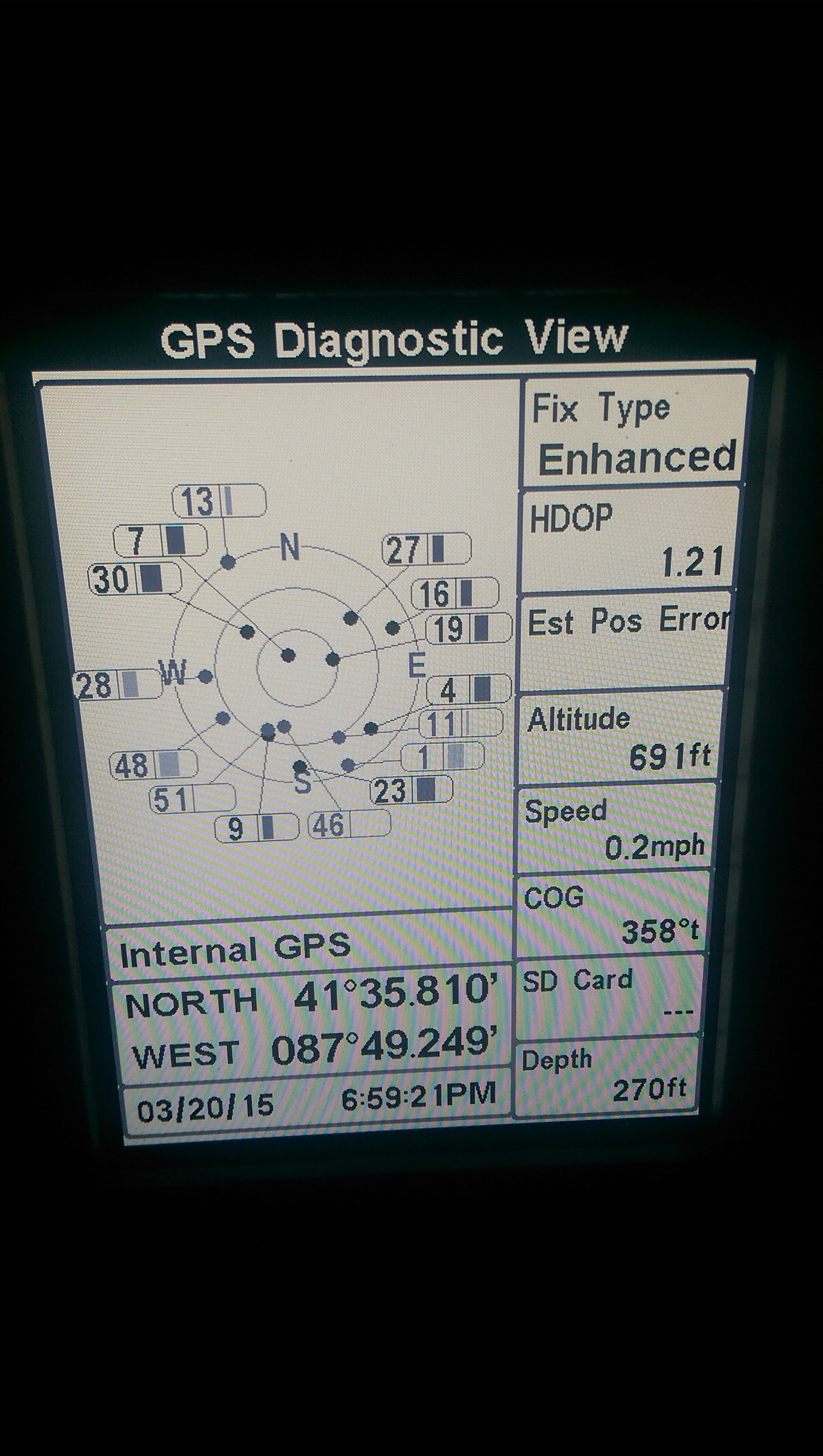
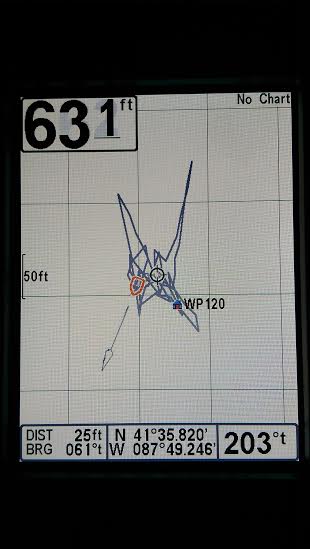
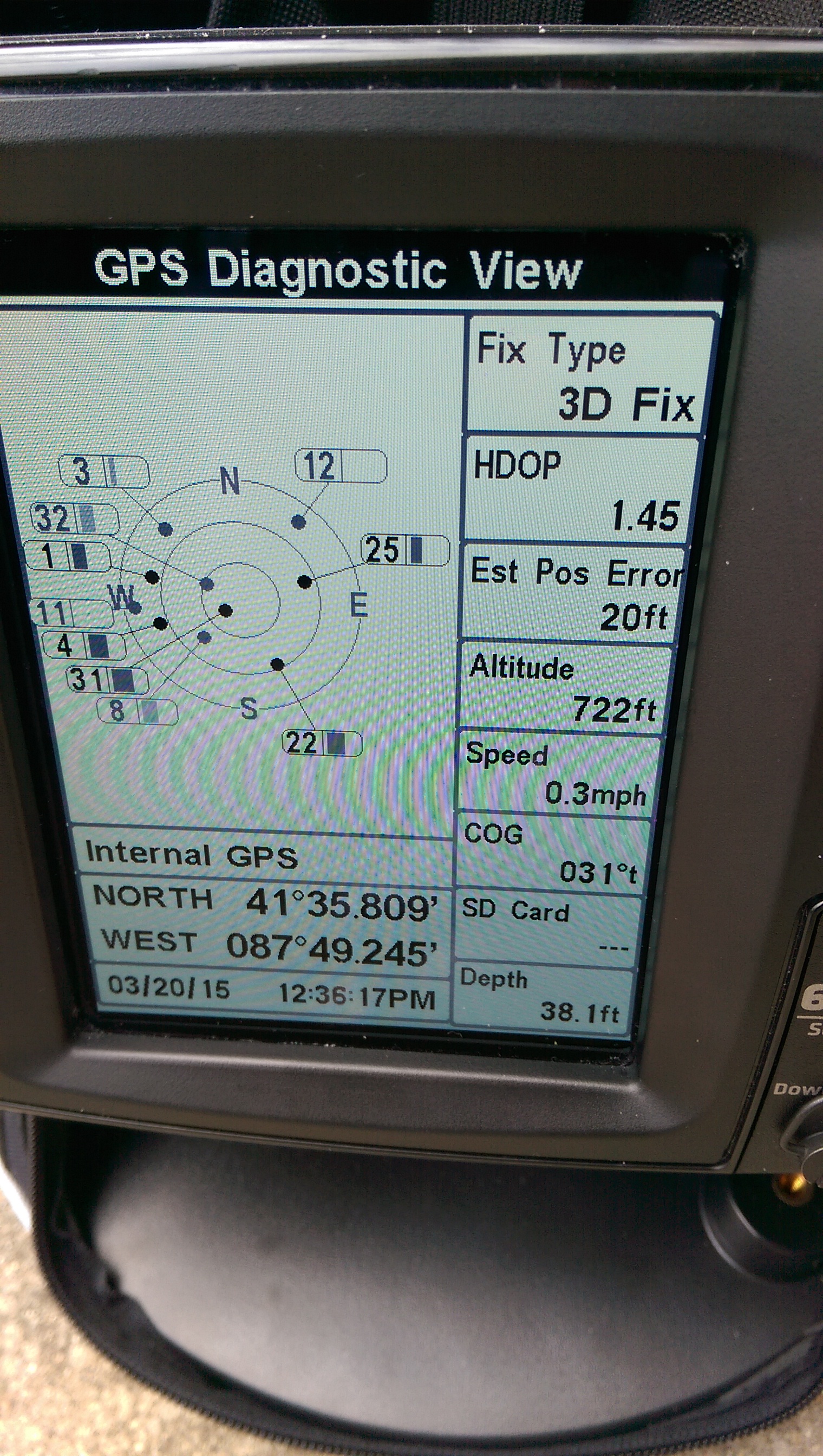
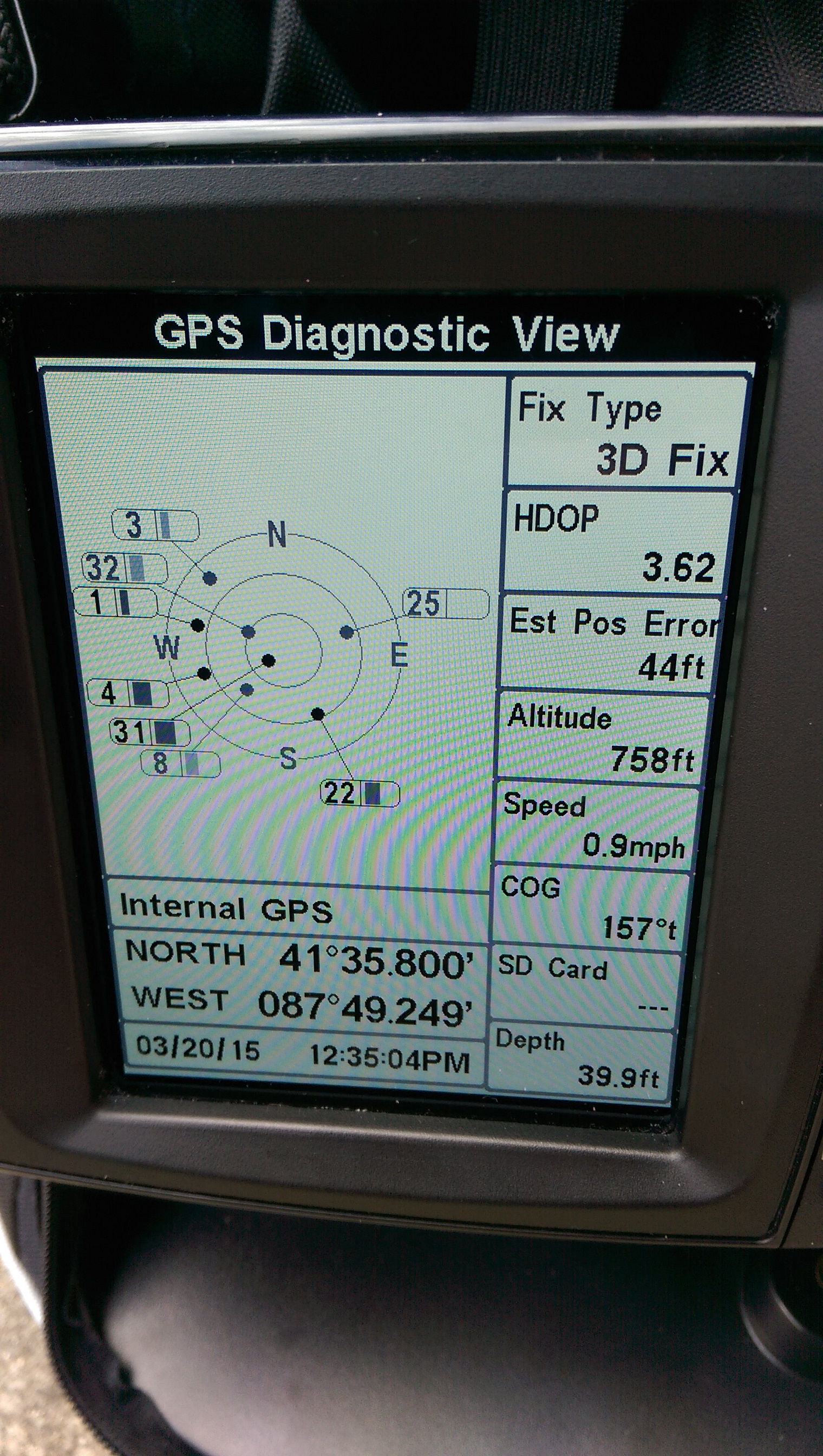
    Thanks for the feedback guys. I’m finding myself leaning towards the Garmin and I honestly don’t know why. My HB has given me some fits, especially with GPS tracking. I’ll mark a waypoint on top of a reef while jigging for walleye in 18fow, come back to that waypoint later in day and I’m in 34fow probably 125ft away. I know they all have some deviance allowance but when finesse jigging an area at least getting close is very important. Also, anything under 3mph was all over on speed, so on the rare occasion of trolling ect speed is all over the place. Its a few years old tho, model 688DI, so I am sure all of the companies have advanced in terms of GPS, especially with the internal antennas.

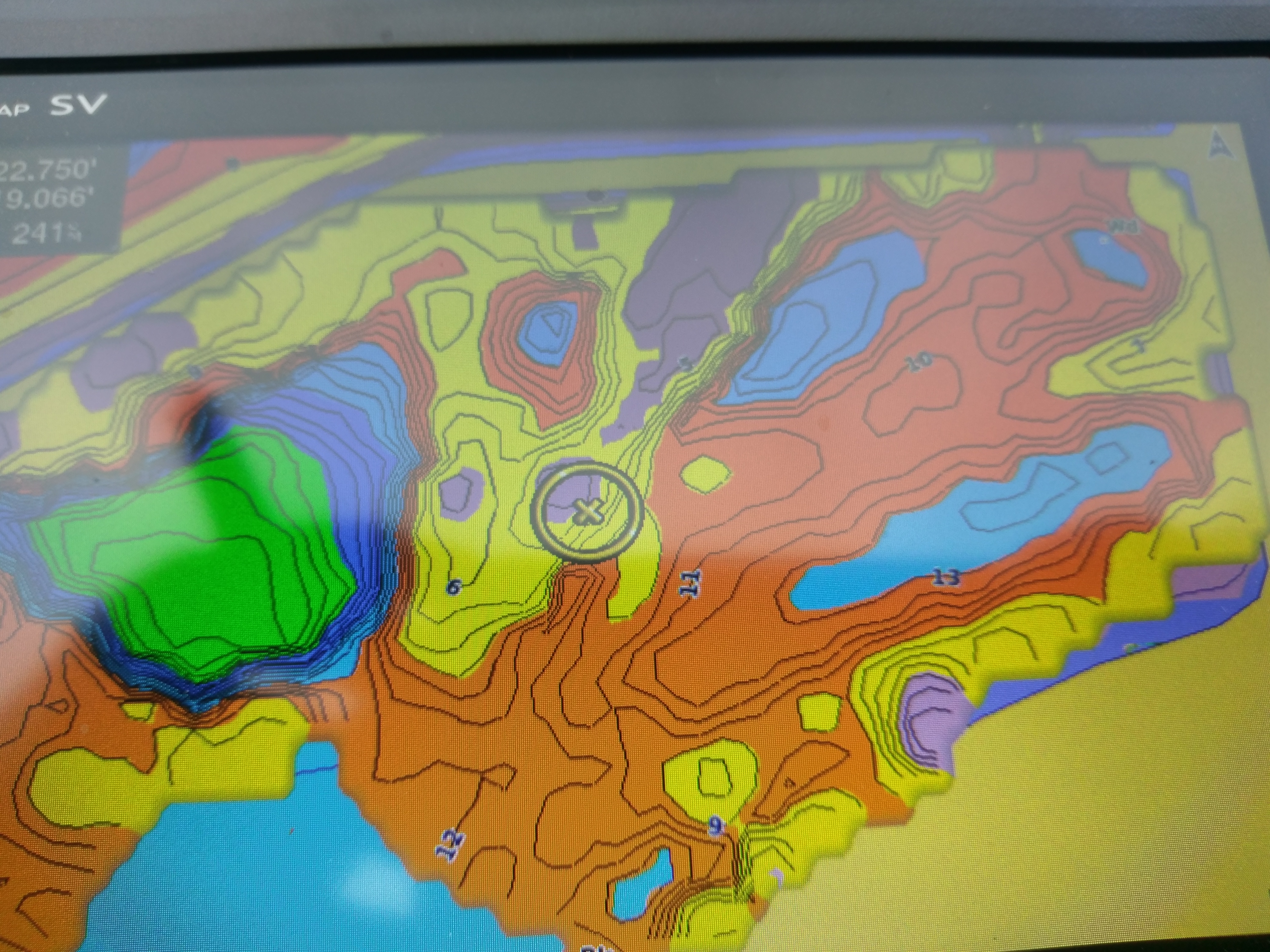
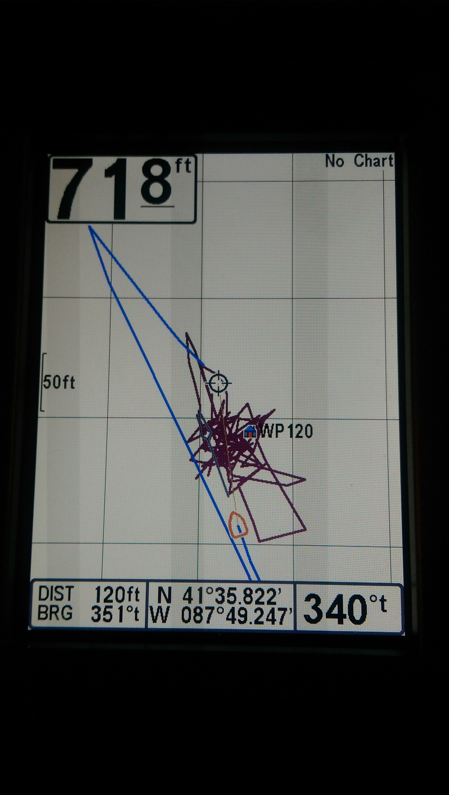
    The one thing I did like about my HB, and I dont even remember how I did it, but I had loaded up google earth, traced out the shoreline of the lakes we fish in Canada that have zero mapping and I was able to convert that into my locator so when boating I at least had a general reference to a spot or area. Although, plenty of times the GPS wasn’t right and I’d be driving over the shore line while out 100ft from shore.

    Pat- I’ve watched some videos that I can find as far as the contour creation process goes, but I have never really heard or read anywhere that describes a little more how many passes for an area to properly build it? Ive watched one where they drove over an area 2-3 times and it changed the contour lines and depth every time. Also, at what speed do you typically draw at? I wonder if it can be too slow, like if we set up to vertical jig a reef area slowly and I left it on, if moving at that slow of a speed does it mess with its building of an area? Also, I would be using the ducer it comes with, I can’t quite swing the Panoptix at this point, lol.

    Thanks again all for the input, anything more on either unit would be helpful. Getting my motor back next week and hoping to get out with a new unit for a few trial runs before Canada in a few weeks. Out for Salmon tomorrow on Lake Michigan yay

    Dan Halicki
    Posts: 26
    #1535375

    So I have done some follow up testing on a few different bodies of water. My accuracy issue appears to be slightly better now, maybe the update did help some. I fished with a friend of mine who has dual Lowrance HDS 5’s in his boat and when comparing the two tracks they were almost identical and I had no fade away as I did before when trolling at slow speeds. When moving at speeds over a few MPH our speeds were completely identical, the low end speed is still junk tho. Trolling at a locked 1.2mph on his unit shows .2-2.6MPH for me, so that is not even close to dependable.

    One thing I have noticed that is odd is that no matter what I can no longer get an Estimated Positional Error number to show. If I scroll to the Diagnostic screen it will show all the satellites that are locked but will not show any EPE at all, if I repower the unit on it might show a random number, say 17ft, and flash that number non-stop on and off without changing the number at all. It also showed “enhanced fix” with no EPE in the middle of the lake and seemed accurate, so I rebooted it to see if I can get an EPE, it then only showed “3D fix” and was flashing 17ft as the EPE and did no change. This is what I saw with the Enhanced fix and no EPE…

    Attachments:
    1. IMAG0686.jpg

    Dan Halicki
    Posts: 26
    #1525461

    Yea now that I am assembling information from this perspective I wish I would have gone with a higher unit, at least one that had an external GPS option. I have a hard time justifying spending so much tho because the Canadian lakes that we fish have zero map options and dont even show up with generic outlines on the factory maps on any of the units…which is crazy since its less than an hour away from Rainy Lake. Also our other big trip takes place in Tomahawk, WI and just have generic outline, which doesn’t even coordinate with unit, it always has me driving on land ect. There are upgraded chips available for the other 4 lakes in the Tomahawk area, just not Lake Alice which we fish. So I have a hard time justifying trying to sell this then spend so much more on an upgrade when I cant take advantage of any of the cool map options out there…even tho this GPS being so inaccurate is very frustrating.

    Dan Halicki
    Posts: 26
    #1525400

    So the update didn’t change much of anything. I completed and verified the update, reloaded unit clear skies out front, let it warm up and start making a track. You can see in this pic there is a fluctuation of about 190 feet north and south and about 60 feet east and west. You can see how dropping a waypoint is essentially pointless with readings like this.

    Attachments:
    1. 415241541.jpg

    Dan Halicki
    Posts: 26
    #1525381

    I can definitely deal with the distance that it would be off between transducer and head unit, I know they say its going to be off 5ft or so, hell I can even deal with 10ft off in reality. But to see tracks that are so far off consistently is aggravating, and marking spots with waypoints that are clearly not even close to where I thought I was when I set it makes it pretty pointless. The speed factor issue does not bother me nearly as much as the inconsistency in GPS readings and how far off tracks and waypoints are. This happens both in Canada and Wisc.

    I went and got an SD card and reader, so hopefully I can get the update completed this afternoon and test it out.

    In the mean time I fired the unit up, let it warm up and gather its satellites for a while and it has been fluctuating between 12ft error to 54ft error quite a bit.

    Attachments:
    1. IMAG0680.jpg

    2. IMAG0679.jpg

    Dan Halicki
    Posts: 26
    #1525336

    Thanks for the replies guys. I wish I was able to find info on this before I purchased this unit. When I was doing my research I found really nothing but good reviews for this unit, including a few guys that owned it. I certainly didn’t expect the performance out of it comparable to the bigger better units that are on some of my friends boats we use on Erie or Miss that are insanely accurate on speed, but I didn’t expect the GPS to be essentially useless.

    You noted the speed accuracy at low speeds is junk, and that I can deal with for the most part because in this boat we are typically either casting or vertical jigging, rarely trolling cranks/spinners. However what about the accuracy issue with waypoints and the tracks being so far off? Being that we vertical jig alot I like to mark waypoints where I am marking schools of fish or catching fish in more open water, having a place to return to. At this point this is no better than lining myself up on markers on land and taking a guess at it when returning.

    For reference, I took a picture of the unit while it was running in my driveway, nothing over the top of it obstructing the view and it had been running for about 45 min. You can see how much travel there has been when not even moving, all of those tracks are from turning it on and not moving it in driveway.

    I did contact Humminbird and they informed me that there is a software update available for my unit, which I plan to do take care of today once I go out and purchase an SD card and a SD card reader. However when looking at the patch notes it doesn’t address GPS readings ect at all, so I am thinking thats a quick answer to get me off their back for now.

    Attachments:
    1. IMAG0674.jpg

Viewing 20 posts - 1 through 20 (of 20 total)