Looks like it’s going to be crazy high on that river system for a long time this year. Lots of rain through out the drainage and add on the melt from 150 to 300 percent of normal snow pack. 
May 29, 2011 at 8:00 am
#1272453
IDO » Forums » Fishing Forums » General Discussion Forum » Missouri River
Looks like it’s going to be crazy high on that river system for a long time this year. Lots of rain through out the drainage and add on the melt from 150 to 300 percent of normal snow pack.
My parents live in Bismarck. They are about 5 or 6 miles from the river. They need to sandbag, they are going to open the gates up to 150,000 Cubic Feet Per Second in June. It’s going to be a mess for a while.
Quote:
Looks like it’s going to be crazy high on that river system
I think you’re crazy high Herb 
Gavins Point is at a record high for water released per second and they are going to double it to 150,000 cubic feet per second.
Boat ramps are all closed right now below the dam.
Been thinking about you already Herb.
Unfortunately for many along the river they are going to experience nothing like they ever have before. There is a large amount of anger being thrown towards the COE, very misguided in my opinion. It’s not like the Corp controls rain and snow fall amounts.
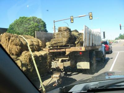
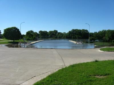
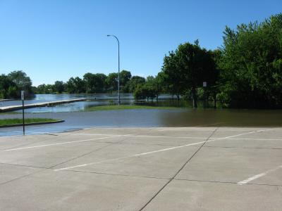
First off imagine this, these pictures were taken this AM, by Thursday the water will be at least 4 feet higher, so not too much imagination on where we will be here shortly…scary.
1st pic is the truckload of empty sandbags going down to get filled up. There was one more box truck following this truck/trailer, full of empty bags.
2nd Here is the boat landing, river is closed
3rd Parking lot will be under shortly
4th Bike trail is under water
5th looking across the river at South Sioux City NE, they will get the brunt of the real bad stuff.
6th Last year this was where the RAGBRI riders were camped at.
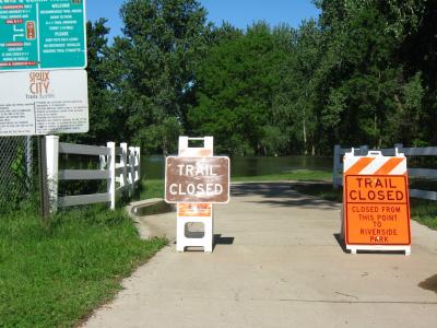
KELO Land has some pretty good photos if you know the areas and can appreciate just how much water is there and yet to come.
The area we hunt in North Dakota on the Sheyenne river is very wet yet. Now the COE is looking at dumping more water into the Sheyenne river and there is nowhere for it to go other than over the bridge and river in our area.
The renters cannot get across the bridge to get thier cows down to calf as thier is already too much water.
The COE’s need to figure out a different way to deal with the water other than just flooding everyone else out.
A few years ago many did not get thier crops in until mid June and many fields were not planted.
Seems like the more they mess with the natural water flow, the worse it gets every spring.
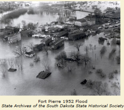
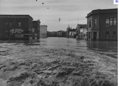
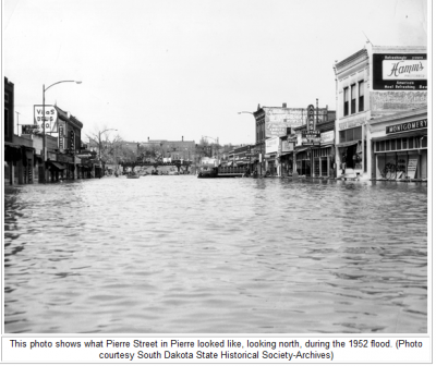
These pics are from 1952 before Oahe was built. Anyone recognize anything?? 
Quote:
Anyone recognize anything??
wow. cant believe the hop scotch was there in ’52.
have spent a few $1 bills in that place
but we usually preferred the “higher class” entertainment down the street at the silver spur/bad river bar. 
on a more serious note … gotta feel for the people along the river in pierre and ft. pierre – yet another flood of historical proportions.
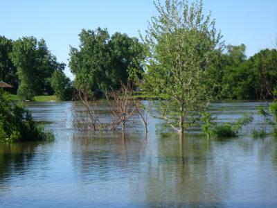
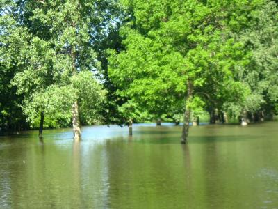
Those pics I took off the boat landing here is Sioux City, they are now saying the water might end up 7 feet higher than the pictures. There are Black Hawk copters hauling in huge sand bags 3 days straight, South Sioux NE will get the worst part, they sit lower than Sioux City. Places up and down the river will all be under water till Sept. Things are going to go from bad to worse next week when the dam at Yankton starts cranking out 3 times the record flow. Up to this point the river is just below flood stage, and that is just from all the rain water.
Flow will go up to 150,000 cubic feet per second. Twice the record amount of 75,000. At least that is what I’ve been hearing.
Oahe will be releasing a 150,000 cubic feet per second starting middle of next week into July. There is a butt load of water to come your way. I heard yesterday several of these dams have never had the emergency spillways ever opened since they were built.
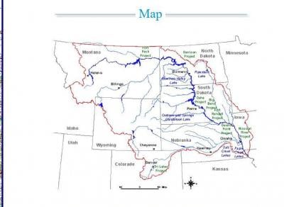
The Missouri River water shed is a massive son of a gun. See the attached pic or link:
Quote:
Oahe will be releasing a 150,000 cubic feet per second starting middle of next week into July. There is a butt load of water to come your way. I heard yesterday several of these dams have never had the emergency spillways ever opened since they were built.
My understanding is the spillway on Sakakewa has never been used, the COE released some water last week and is making sure it usable, the COE said they dont know how the water will flow once opened? poor people down stream are having a tough time, I cant believe they let people build in a flood plane! 

Back when the idea of damming the Missouri was put on the table, a warning was issued of something like this happening in the future. Most of those towns, homes, and farms were there long before the dams and people dealt with what nature dished out.
“I can’t believe they let people build in a flood plain”, is like saying I can’t believe they let people build in areas of a hurricane happening, tornado alley, an earth quake fault line, or just about any place on this earth where mother nature might put a hand on you.
everyone lives in a flood hazzard area, just to what degree of flooding. FYI flood insurance is available to everyone, don’t wait to protect your assets till the water in lapping at the front door. If there has been a flood where you live in the past 50 years, chances are there will be another. I have done the max $250,000 policies for $461-$1,200 depending on the NFIP number and flood zone map giving the degree of flood probability.
Quote:
Back when the idea of damming the Missouri was put on the table, a warning was issued of something like this happening in the future. Most of those towns, homes, and farms were there long before the dams and people dealt with what nature dished out.
“I can’t believe they let people build in a flood plain”, is like saying I can’t believe they let people build in areas of a hurricane happening, tornado alley, an earth quake fault line, or just about any place on this earth where mother nature might put a hand on you.
If you notice (in Bismark) most of the homes in danger were built in the last 20 years near the river-the homes that are in danger were not there when I grew up in Bismark,sorry for the misunderstanding
Guys, I missed this thread somehow but I posted some recent pics in my report here:
You must be logged in to reply to this topic.