Waypoint management with Humminbird PC

  • jhalfen
    Posts: 4179
    #1294849

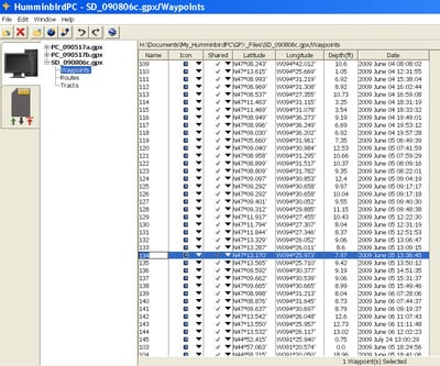
    With a half-summer’s worth of waypoints generated on my Humminbird 997 and 1197, it’s time for me to organize them for ease of use and for future reference. To do so, I make use of Humminbird PC. Humminbird PC is a waypoint management program that is available to owners of Humminbird chartplotters and GPS/sonar combo units. Registered owners of these units can download Humminbird PC from the Humminbird website, as quickly and easily as you would download a software update for your unit. And best of all, Humminbird PC is free!

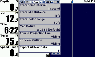
    After downloading and installing Humminbird PC on your computer, you need to download waypoints and navigation data from your Humminbird unit in your boat. Doing so is easy. Install an SD card into one of the slots in your unit, and use the menu system (press the Menu button twice) to go to the Navigation Menu tab. Arrow down to “Export all Nav data” to write waypoints and navigation data to the installed SD card (you may need to change your user mode to “advanced” in order to see this particular menu choice).

    Waypoints and navigation data will now be written to your SD card. Remove the card from the unit and bring it to your PC.

    jhalfen
    Posts: 4179
    #795768

    When you open Humminbird PC, you’ll see a pair of images in the upper left hand corner of the screen: a PC and an SD card.

    Under the SD card image, you’ll see a pair of arrows; one to download information from the SD card to the PC, and one to upload information from the PC to the SD card. To get started using Humminbird PC, install the SD card into your PC’s SD card reader, and download data from the card to your PC. Doing so will write a .GPX file, with waypoints, routes and tracks, using the data from the SD card. The .GPX file is the storehouse for all of the data read and manipulated by Humminbird PC.

    jhalfen
    Posts: 4179
    #795772

    Selecting “waypoint” from under the SD card’s .GPX file will provide you with a list of all of your waypoints, including their waypoint number, icon, position, depth, and so forth. To manipulate a particular waypoint, simply click on that waypoint’s line of data. Let’s spend some time looking at waypoint 134.

    jhalfen
    Posts: 4179
    #795774

    Wondering where waypoint 134 is? Use Humminbird PC’s interface to Google Earth to find out. By selecting waypoint 134, and clicking the blue and white Google Earth icon at the top of the window, the precise position of waypoint 134, overlayed on a Google Earth’s satellite image, is produced. I collected waypoint 134 while pre-fishing the FLW walleye league event on Leech Lake this June. That’s one of the Duck Points….Second Duck Point, I think.

    jhalfen
    Posts: 4179
    #795776

    Let’s use that information to modify the settings for waypoint 134. First, let’s change its name from 134 to Duck Pt 1. Simply click on the original name (134) and type the new name. Then, let’s change its icon from a boring blue circle to a fish (first column to the right of the waypoint name), as we caught a bunch of nice tournament fish right there on Second Duck Point. A variety of icons are available, including weeds, trees, boat ramps, and other icons that are relevant to boaters and anglers.

    jhalfen
    Posts: 4179
    #795782

    When you’re done working with your waypoints, uplod your work back to the SD card and install the card in your Humminbird unit in the boat. Waypoint management project complete!

    Many of these tools are available right on your Humminbird head unit, but I think that Humminbird PC makes the job easier, faster, and more comfortable on the eyes.

    New Humminbird waypoint management tools are in the wings for 2010….stay tuned for more information on how Humminbird makes waypoint management quick and easy!

    nic-habeck
    Lake Mills, WI
    Posts: 831
    #795783

    Excellent post Jason. Thanks!

    Pete Bauer
    Stillwater, MN
    Posts: 2593
    #795787

    Ok Jason, that’s just cool!

    Randy Wieland
    Lebanon. WI
    Posts: 13302
    #795789

    J- I’ve been using it for the last couple years now. As you stated, it is very user friendly and easy to use. The one thing I have begged Humminbird to change is the number of characters you can have in the waypoint name. Great for a guy that only fishes a few bodies of water. Pull up my global screen and it looks like the bombing of Europe. To complex to have a overly complicated naming scheme.

    Also, the Google Earth is a super-cool function. Just beware of the memory requirements it has for lessor machines or older versions of windows. I suggest if anyone loads Google Earth for the first time, do the minimal install without all the toolbars and other junk. I made that mistake once and had to remove-reinstall to get it to work on my PC. Just my two cents. and Jason, I beginning to think you gave up on fishing and just putz around in the boat playing video games

    jhalfen
    Posts: 4179
    #795841

    Quote:


    Jason, I beginning to think you gave up on fishing and just putz around in the boat playing video games


    Hey, I caught these fish less than 24 hours ago!

    bear schutts
    Menomonie, Wisconsin
    Posts: 24
    #795852

    Thanks Jason. I have just started working with the Humminbird PC and new to the Humminbird units. Great post helps a lot.

    Randy Wieland
    Lebanon. WI
    Posts: 13302
    #796493

    Quote:


    Quote:


    Jason, I beginning to think you gave up on fishing and just putz around in the boat playing video games


    Hey, I caught these fish less than 24 hours ago!


    Thats a great way to redeem yourself

    jhalfen
    Posts: 4179
    #796506

    And then these over the weekend!


    KirtH
    Lakeville
    Posts: 4063
    #797195

    Thanks, I need to do this.

    I am telling you million dollor idea, add this to the

    KirtH
    Lakeville
    Posts: 4063
    #797372

    This is way to cool, just got done playing with the program. Cleaned up and reanmed some secret spots

    KirtH
    Lakeville
    Posts: 4063
    #797385

    I am going to really like this system, I run 3 Birds, the 1157 on the bow and the 788 as a gps only are interlinked together, and 997 is standalone, I can mark areas of interest on my SI transfer them to the putor, edit and relaod them to the interlinked system, sweet

    KirtH
    Lakeville
    Posts: 4063
    #797388

    Oh yah the Google thing is really a neat function. Lets see which one of those boats from the satallite view is jason

    jhalfen
    Posts: 4179
    #797390

    My boat uses stealth technology to make it invisible in satellite images. All very hush-hush, you know.

    With only 6300 acres, there are few secrets on the backyard gem.

    absolute2ks
    Chippewa Falls, WI
    Posts: 674
    #797405

    Quote:


    My boat uses stealth technology to make it invisible in satellite images. All very hush-hush, you know.

    With only 6300 acres, there are few secrets on the backyard gem.


    I will be selling the secrets around the 10th of Sep.

    kbush
    Minneapolis, MN
    Posts: 83
    #1392087

    Old thread, but does anyone know if the waypoints are only stored temporarily in google earth? AKA, not stored on Google earth for others to view. I assume temporary as lakes would like be littered with way points.

    flatfish
    Rochester, MN
    Posts: 2105
    #1392389

    darn good post Jason H.
    I haven’t used HBird PC, but I think I’ll be loading it come morning….years ago I had a notebook in the boat to tell me what the heck that way point was! This is for sure going to be cool!

    red89
    Hudson
    Posts: 918
    #1571469

    Found this post very useful, as I just started messing around with Humminbird PC.

    My question is, is there a way to delete all waypoints on your unit? I have hundreds of waypoints from previous owner that I don’t want on there. I have an old 757c, and it seems i can only select one way point at a time which would take hours.

    For some reason I thought if I deleted them on humminbird PC, then plugged the SD card back into my unit it would wipe out the previous data and just load the new data, but apparently that is not the case.

    Thanks,

    rnvinc
    West Ky
    Posts: 2
    #1571512

    My question is, is there a way to delete all waypoints on your unit? I have hundreds of waypoints from previous owner that I don’t want on there. I have an old 757c, and it seems i can only select one way point at a time which would take hours.

    For some reason I thought if I deleted them on humminbird PC, then plugged the SD card back into my unit it would wipe out the previous data and just load the new data, but apparently that is not the case.

    Thanks,

    For your 757 … Look under the Setup tab for “Format Nav Directories” …

    Rickie

    red89
    Hudson
    Posts: 918
    #1571522

    Figured it out thanks to this video.

    Craig Sery
    Bloomington, MN
    Posts: 1178
    #1727236

    Can you manually enter waypoints in Humminbird PC then download them to your unit?

    gotalunker
    Zimmerman, MN
    Posts: 153
    #1733986

    Can you manually enter waypoints in Humminbird PC then download them to your unit?

    Craig, the answer is “yes”!
    I’ve done this by right right clicking any location in Google Maps and entering the coordinates into Humminbird PC.

    But I have to be honest, you can also manually create waypoints in Google Earth and eventually download them into your unit as well – and this is much easier IMHO.
    Today I just posted a high level overview post in the Ice Fishing Forum. It is titled “Humminbird PC”

Viewing 28 posts - 1 through 28 (of 28 total)

You must be logged in to reply to this topic.