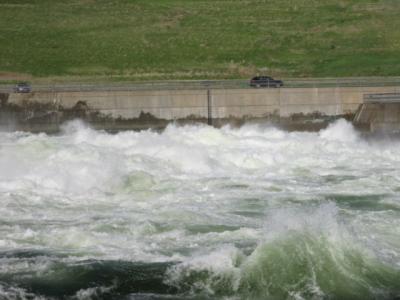
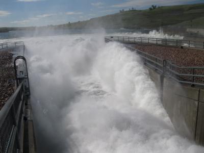
Got these from Mom over the weekend. This is of the emergency spillways that runs into the Stilling Basin.

May 23, 2011 at 2:53 pm
#1272384
IDO » Forums » Fishing Forums » General Discussion Forum » Oahe Emergency Spillway Pics
Got these from Mom over the weekend. This is of the emergency spillways that runs into the Stilling Basin.
The last time I saw these opened was in 97 during the highest water ever on Oahe. Standing along the railings was rather intimidating!!
Its hard to believe that in 2006 the water wasn’t within a quarter of a mile of the spillway much less going over it. Absolutely amazing.
Quote:
Its hard to believe that in 2006 the water wasn’t within a quarter of a mile of the spillway much less going over it. Absolutely amazing.
I wonder how many cannon balls were wrapped around those submerged intakes? I know we lost one there.
Surf’s UP! I hope they dont flush the forage out of the system again.
Here is some info in the local paper:
Quote:
State officials are alerting residents along the Missouri River in South Dakota to prepare for higher water levels as the Corps of Engineers begins to increase releases from the dams. Winter snowmelt and spring rains have raised some of the Missouri River reservoirs close to record levels. Governor Dennis Daugaard ordered the State Emergency Operations Center to be activated effective today, to allow officials to better respond to the increased flows on the river. Releases from Oahe Dam north of Pierre started to pick up yesterday and further increases are planned for today and again later in the week.
Eric Stasch, Operations Manager for Oahe Dam says storms that hit eastern Montana, eastern Wyoming and western South Dakota and North Dakota left significant moisture, which in turn is impacting the Missouri River system. Stasch told the Pierre City Commission yesterday that this week will bring releases from the dam that will break previous levels. In 1997, he says 60,000 cubic feet per second of water was dumped during a time of excess moisture. Starting today, he says the dam will dump 70,000 cfs and that level will increase to 75,000 cfs by Thursday. Water releases are expected to reach 85,000 cfs sometime over the Memorial Day weekend. That will raise water levels on the river significantly, especially in the Pierre and Fort Pierre area and in locations downstream from Fort Randall Dam to below Gavins Point Dam. Officials say it’s uncertain how long the increased releases will continue but it could be a number of weeks. Stasch says even though the record levels of water will be dumped from Oahe, he’s confident that the dam can handle the job.
The Missouri dumps into the Mississippi not very far north of St. Louis so Herb is safe up in Iowa—at least from this end of it. It is a crazy year everywhere—thats for sure!
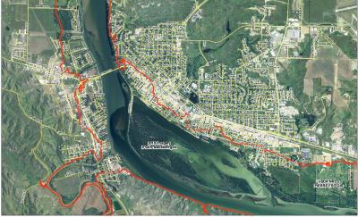
The red line in the attached image represents the potential flooded areas of Pierre and Fort Pierre due to high waters on Oahe and the Corp being forced to release excessive amounts of water.
Feel bad for you folks that have to deal with this.
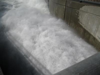
A video from the emergency spillway in the stilling basin. Amazing how powerful water is.
We just canceled our trip next week staying about one mile below the spillway! Dammmmmmm!
You must be logged in to reply to this topic.

