This Friday at Lienies Lodge from 5-8. This looks like a real keeper. I might even get out and fish Wissota this year 
http://chippewa.com/news/local/article_eab07c9c-2053-11e0-bda9-001cc4c002e0.html?mode=story
IDO » Forums » Fishing Forums » Wisconsin Lake & Rivers » Wissota, Lake » Free beer and new free Wissota lake map!
This Friday at Lienies Lodge from 5-8. This looks like a real keeper. I might even get out and fish Wissota this year
http://chippewa.com/news/local/article_eab07c9c-2053-11e0-bda9-001cc4c002e0.html?mode=story
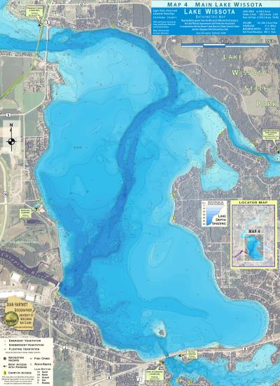
Its some of the best mapping I have seen with contours into tributaries to date. It does not have gps coordinates which makes finding things a bit more interesting.With a little research you can get gps coordinates for the newly placed reefs & cribs. The price is the best part = FREE  Heres to free maps & cold brewskis at the lodge!
Has anyone seen the map yet? Just wondering if it is as good as advertised?
Quote:
Its some of the best mapping I have seen with contours into tributaries to date.

It’s FREE!!!! 
 How can you get better than that? It looks good,not great but still… I like it,pick it up and check it out.
Map sets are available from:
Absolute PowerSports
DNR Regional Office, 1300 West Clairemont, Eau Claire
Gordy’s Hardware, Lake Wissota and Chippewa Falls
Bill’s Sport Shop, Chippewa Falls
Lafayette Town Hall
Quote:
That new lake map is unbelievable. Do you guys have any idea how on Earth they can be giving those things away for free. The thing is very nicely detailed, in color, and virtually indestructible. I was looking at it this weekend and just couldn’t believe it was free. Was there a grant of something granted to the group that put it together? What made me think of the map is all this talk of cribs. You could darn near walk across the lake on the cribs. Especially those on the West side of the lake. Should be a handy little scouting tool.
The map was funded by a WI DNR aquatic invasive species control grant and Xcel Energy.
The primary goal was to develop a plant management plan.
Sully
You must be logged in to reply to this topic.