The “can line”. What will become of it?

  • Brian Klawitter
    Keymaster
    Minnesota/Wisconsin Mississippi River
    Posts: 59940
    #2163968

    Passing along a letter from the LPLA:

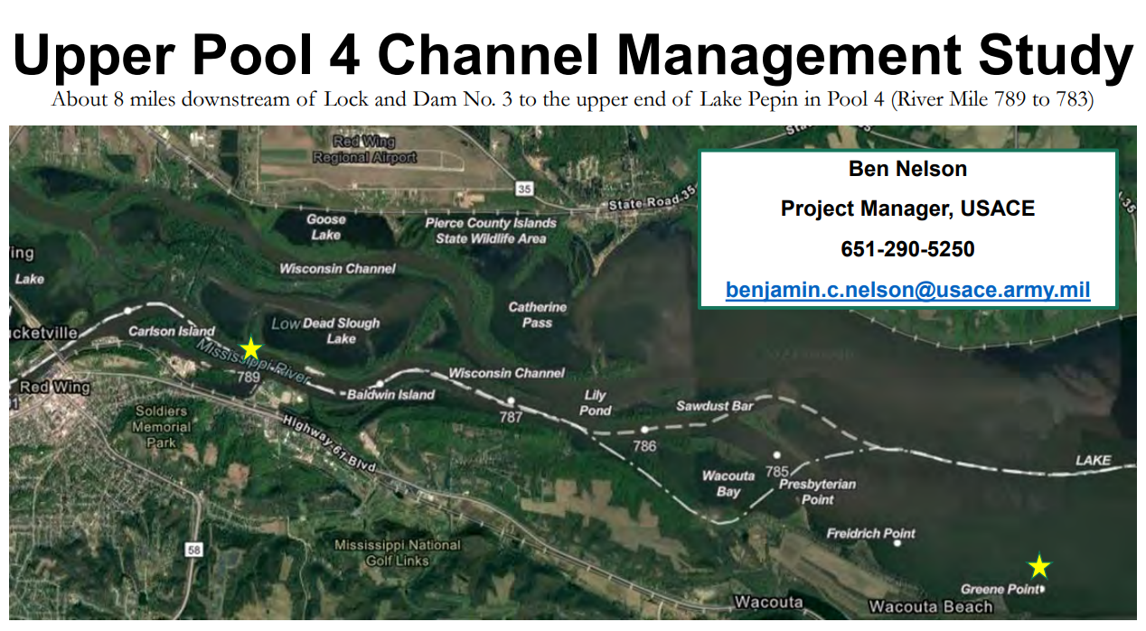
    We have some exciting news to share with you! Last week we learned the Corps of Engineers approved $500,000 to study a long-term solution to improve navigation in the narrow channel at the head of Lake Pepin between river mile 789 (Colvill Park) and 783 (Green’s Point).

    This stretch of the river is the most difficult to navigate in the entire St. Paul District from Minneapolis, Minnesota to Dubuque, Iowa. According to the Corps’ dredging manager, “even if we were able to dredge all of it (and find placement sites for the material), that doesn’t mean it would hold over a period of time.” The study will be an evaluation to see if there is something that can be done to make it / keep it more navigable over the long-term. The Corps expects to have outcomes from the study available sometime after the fall of 2023.

    LPLA has been advocating for improved safety in this area for years and we continue to stay in close contact with the dredging manager. The Corps will announce the study to their broader river network (state and federal partners) later this week. The strength of our network and individual relationships means we can join their interagency meeting (the River Resources Forum) primed with information and questions.

    I want to thank you, in particular, for the essential support you provide as a member of LPLA. We are the squeaky wheel finally getting some oil, and our momentum will only continue. Please reach out anytime with questions or comments (630) 806 – 9909. I will continue to keep you informed!

    All my best,
    Rylee Hince
    LPLA Executive Director

    Huntindave
    Participant
    Shell Rock Iowa
    Posts: 2947
    #2164003

    Tried to look it up and this is all I found;

    “What does LPLA stand for? – Abbreviations.comhttps://www.abbreviations.com › LPLA
    Couldn’t find the full form or full meaning of LPLA? Maybe you were looking for one of these abbreviations: LPJO – LPK – LPKI – LPL – LPL PB – LPLB – LPLC …”

    luttes
    Participant
    Maplewood/WBL
    Posts: 542
    #2164014

    Whatever they do, BK, those pesky walleye fisherman are still going to get in your way jester

    eyeguy507
    Participant
    SE MN
    Posts: 4507
    #2164029

    I won’t be getting in the way! I always struggle near that can line! Seems like anytime I think to fish it, all the barges decide to pass just before me doah

    Brian Klawitter
    Keymaster
    Minnesota/Wisconsin Mississippi River
    Posts: 59940
    #2164042

    Whatever they do, BK, those pesky walleye fisherman are still going to get in your way jester

    Or I’ll be in their way! crazy

    snelson223
    Participant
    Austin MN
    Posts: 453
    #2164100

    I would like to see the Wacouta area dredged out more. That area has silted in really bad.

    Brian Klawitter
    Keymaster
    Minnesota/Wisconsin Mississippi River
    Posts: 59940
    #2164135

    I would like to see the Wacouta area dredged out more. That area has silted in really bad.

    and that is the “main” reason for the LPLA or at least why it was started. It was hoped that the COE would clean out that side along with the work that will be starting this spring on the Bay City side.

    If dredging is the only work the COE will be doing along the can line, no big deal…but I’m not sure why they would need to spend $500K for a study.

    I’m by no means an arm chair expert, but it just seems that this area needs more flow to keep the sediments and sand from dropping out of the river at this point.

    One way to do this would be to make a narrow channel further into the lake where the sediments would/could be scattered over a larger area.

    Keeping in mind the Corp doesn’t do much without river commerce/navigation as the foundation of the action. If it helps the fish/endangered clams/wildlife, well that’s nice but not the reason the action was taken.

    Just in case anyone gets the wrong idea, I don’t hate the Corp. In fact, I have a number of friends that work for the Corp. It’s congress that makes their laws and rules I can’t stomach.

    Brian Klawitter
    Keymaster
    Minnesota/Wisconsin Mississippi River
    Posts: 59940
    #2164136

    One way to do this would be to make a narrow channel further into the lake where the sediments would/could be scattered over a larger area.

    ** this is my speculation.

    Tom P.
    Participant
    Whitehall Wi.
    Posts: 3446
    #2164161

    I got stuck on half a million just for a study. flame chased

    buckybadger
    Participant
    Upper Midwest
    Posts: 7175
    #2164167

    Hopefully the can line stays intact. I love it because it’s a boat magnet to keep anglers away from other spots. Show a net there on a sunny weekend day in Late April/Early May and you will have people on you in no time.

    KPE
    Participant
    River Falls, WI
    Posts: 1487
    #2164177

    500k pays 3 upper mid-level engineer salaries for a year, plus a few thousand in incidentals or supplies. Makes sense to me, and that’s the way the world is working now.

    Brian Klawitter
    Keymaster
    Minnesota/Wisconsin Mississippi River
    Posts: 59940
    #2164698

    A bit more info came out last night.

    All,

    I wanted to keep you apprised of a recently approved channel management study at the head of Lake Pepin between river mile 789 and 783. The Corps of Engineers has kicked off this study in an effort to:

    Reduce the need for dredging in this area.

    Improve channel conditions for commercial and recreational traffic.

    Increase / maintain channel widths

    Support safe navigation in the future.

    The potential features being considered (at this point) include wing dams, rock revetment, and rock closures. The Corps is NOT looking at ways to reduce sediment input as part of this study.

    The tentative schedule for the study is as follows:
    May 2023 – propose a list of alternative measures.
    December 2023 – prepare a draft report.
    Fall 2024 – prepare a final report.

    At some point in this process there will be an opportunity for public comment. At this point, the Corps is uncertain whether ANY option is viable to meet their objectives, but will be modeling various alternatives.

    As key river users, I would love to know if you have any initial thoughts, questions, or concerns about the study underway. I’m happy to set up a meeting to discuss or wait to discuss when the alternatives have been developed.

    The Project Manager’s contact information is included on the attached map. Feel free to email this group or give me a call directly if you have initial thoughts. (630) 806 – 9909.

    Thank you for your time and input!

    Rylee

    Attachments:
    1. Channel-Management-Study.png

    Netguy
    Participant
    Minnetonka
    Posts: 2418
    #2164710

    Any idea where the river mileage is measured from?

    Brian Klawitter
    Keymaster
    Minnesota/Wisconsin Mississippi River
    Posts: 59940
    #2164739

    The Upper Mississippi River at the confluence of the Ohio is Mile Marker 0. That’s just South of St Louis MO.

    MM 953 starts at the Ohio and runs down the the gulf where MM 0 is located.

    Don’t ask me the reasoning… that’s just the way it is.

    docfrigo
    Participant
    Wisconsin
    Posts: 1564
    #2168727

    Closing dams, rip rap and wingdams— count me in!!!!!

    Justin Donson
    Participant
    Posts: 337
    #2168737

    500k pays 3 upper mid-level engineer salaries for a year, plus a few thousand in incidentals or supplies. Makes sense to me, and that’s the way the world is working now.

    Keep in mind salaries aren’t the whole picture. We normally add on 40% or so to estimate cost for a ‘fully loaded’ employee. That’s not just salary, but benefits, equipment/technology, etc.

    So probably more like 2 mid-level engineers lol.

    Cooperman
    Participant
    Nevis, Mn.
    Posts: 127
    #2177031

    Not a river fisherman, just curious, where and what is the can line?

    Justin Laack
    Participant
    Austin,mn
    Posts: 464
    #2177048

    It is the upper end of lake pepin, where the navigation channel narrows way down with channel markers on both sides of it. From Presbyterian point down to Green point.

    Cooperman
    Participant
    Nevis, Mn.
    Posts: 127
    #2177052

    It is the upper end of lake pepin, where the navigation channel narrows way down with channel markers on both sides of it. From Presbyterian point down to Green point.

    Thanks Justin

Viewing 20 posts - 1 through 20 (of 20 total)

You must be logged in to reply to this topic.