Never looked at getting one of the cards before, but recently purchased a helix 7 that can take a card like that. What do i gain with one of them over the standard maps already on my helix unit. Have the helix 7 g2si with the winter ice kit if that matters.
IDO » Forums » Fishing Forums » Toys for Big Boys » GPS Mapping » Navionics / lakemaster card
Navionics / lakemaster card
-
 David Blais
Posts: 764December 24, 2018 at 8:04 pm #1820301
David Blais
Posts: 764December 24, 2018 at 8:04 pm #1820301I would buy lake master over navionics. It seems to be more accurate in most situations
December 24, 2018 at 9:50 pm #1820330The built-in maps are commonly in 10-foot contours, sometimes 5-foot contours and are derived from DNR maps often done many years ago with a lead weight and surveyed positions on the ice. Modern map cards use satellite GPS positioning and sonar depth recording, with contours as precise as 1-foot intervals. They can make a world of difference in your positioning. Check the lake list on the Humminmbird website and see if the lakes you fish are listed and if they are high-definition maps. Navionics has an online web app you can view lakes before you buy. Lakemaster is in my opinion better than Navionics.
 tbro16InactiveSt PaulPosts: 1170December 25, 2018 at 4:10 am #1820361
I had never purchased a map chip prior to last year. Ended up picking navionics because I wanted the contour map for a few lakes in MN, WI, as well as a lake I fish in Ontario. Bought the “Navionics Plus North America” chip and I am pretty disappointed with it. Not precise at all. Doesn’t show humps, tight breaks, boat landings, or hazards on the lake in canada. Havent had the same issues for the lakes around here, but it still isn’t anywhere near dead accurate. Will try lakemaster for my next purchase. Google “navionics chartviewer” if you want to see what the contours will look like for the lakes you fish.
December 25, 2018 at 6:31 am #1820370Bought the “Navionics Plus North America” chip and I am pretty disappointed with it. Not precise at all. Doesn’t show humps, tight breaks, boat landings, or hazards on the lake in canada.
Did you have the “Fish-n-chips” feature turned on? That’s a “feature” of Navionics that shows 1-foot contours on some lakes, but still seems to be just drawn in between 10-foot contours in most cases. Not to be trusted until you’ve verified it on the water. You have to go into the settings for your charting and dig around until you find it and turn it on.
Humminbird now has an Ontario card, but no high-definition contours on anything but border waters. Here’s the lake list:
December 25, 2018 at 6:42 am #1820371I haven’t found any chip to have much for Canadian waters. Both nav chip and lake master are pretty close for most bodies of water each have other better. Navionics at least has more then one state on a chip so if you only fish the bigger waters beater to by nav. Unless you want to utilize Ipilot link features.
tbro16InactiveSt PaulPosts: 1170December 25, 2018 at 5:36 pm #1820449Did you have the “Fish-n-chips” feature turned on? That’s a “feature” of Navionics that shows 1-foot contours on some lakes, but still seems to be just drawn in between 10-foot contours in most cases.
I’ve never heard of such a thing, so I doubt it! Play with the settings on my humminbird or on the navionics website?
December 26, 2018 at 9:29 am #1820528I prefer Lakemaster for most things since I use Humminbird units and like their feature integration. I’ve been very satisfied with the accuracy just about everywhere that I fish in WI, MN, as well as the southern portions of LotW. We’re planning a trip to the northern portion of LotW next year, and Lakemaster does not offer any data for that portion of the lake. It’s just a big blank on the LotW/Rainy chip.
However, my Helix unit comes pre-loaded with the ContourXD map which includes coverage of the northern portion of LotW; relatively low detail since it is the same information as the Hydrographic paper maps or the old Navionics info. Good enough to get around but not fishing-level detail on spots.
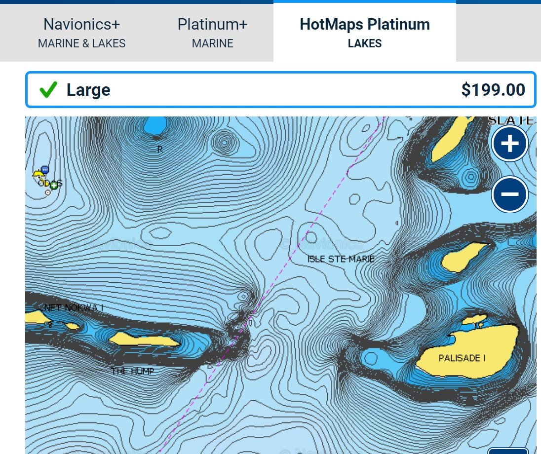
This is also the same exact info that you see when visiting the Navionics ChartViewer app online.Interestingly, when you visit the product pages for the Navionics map chips, it allows you to zoom in and see the coverage detail. Both the Navionics+ and HotMaps Platinum chips appear to include 1′ contours for the northern portion of LotW – as well as other lakes in Canada. Certain lakes do not have that level of detail, and certain ones do. So, it looks like you’re able to check on the specific waters you’ll be fishing before deciding to buy.
Has anybody used one of these chips on the northern end of LotW to offer additional insight?
Attachments:
navhotmaps.jpg
navchartviewer.jpg
February 2, 2019 at 12:04 pm #1831955Every lake map is going to be different, lake by lake. You can preview Navionics mapping online https://webapp.navionics.com/?lang=en#boating@6&key=gdapGfskwP
Make sure to view the high definition Sonar Chart layer by clicking on the icon lower left corner and selecting the SONARCHART layer.When you install the card in a your sonar make sure to go to the settings and select Sonar chart or Fish n Chip depending on manufacture or software version.
Navionics+ regions and Hotmaps Platinum have SonarChart layer installed already but make to plug you card into to your computer and update the sonarchart data.
Navionics+ US and Canada you have to select an area and download the Sonar Chart layer for the lakes or area you are fishing.
The same Data is available on the mobile app.
They do have a Trade in and up program Trade In Rebate.
Link: https://www.navionics.com/usa/lp/rebate?utm_source=mailchimp&utm_medium=email&utm_campaign=tradein_2019-sponsors&utm_content=logoParticipant
Posts: 1June 18, 2019 at 4:22 pm #1862872I have had Navionics on my Humminbird 598 and like it well. Just purchased Lakemaster for my Helix 7 DI GPS. Was very disappointed to discover that the options for the Helix 7 was much different (generic) than for the Solix or Onix models. The color options were very limited. Called Hummminbird reps. Even though they were courteous they did not appear to have any real world experience with the software. Trying to get an apples to apples comparison is very difficult. Going to try Navionics next.
June 19, 2019 at 7:42 am #1862941You can view all of Navionics Charts online on the Cartviewer page https://webapp.navionics.com/?lang=en#boating@6&key=kuatGrovvP
Make sure you click on Navionics symbol lower left and select the high def SonarCHart Layer.Depending on the area you fish you could go with Navionics+ regions which is preloaded Or Hotmaps Platinum which gives some other features such as shaded relief, satellite overlay
If you fish outside the region lets say the north area you can get Navionics + US and Canada, you just have to download the SonarChart layer for the lakes you fish or frequent.
When you get the card plug it into your computer and register and update it with all the most current detail or data.
Smellson
Posts: 306June 19, 2019 at 8:15 am #1862944I prefer lakemaster mapping over navionics on just about every body of water I have fished (exception being Lake Pepin). Depending on how many lakes you fish, the a la carte option with lakemaster may be a good deal. $10/lake and you just upload them to your own personal sd card. That way you don’t have to buy several $100 cards just to cover several states. I actually just used this for the first time as I have a couple lakes in Wisconsin that I fish but didn’t feel the need for the $100 chip. Worked great.
Viewing 12 posts - 1 through 12 (of 12 total)
You must be logged in to reply to this topic.