MN/WI border at L&D #3. Where is it?

  • Brian Klawitter
    Keymaster
    Minnesota/Wisconsin Mississippi River
    Posts: 59940
    #1603755

    So FBRM and I were chatting in the boat a couple weeks ago and were a person could use 3 hooks per angler below the dam.
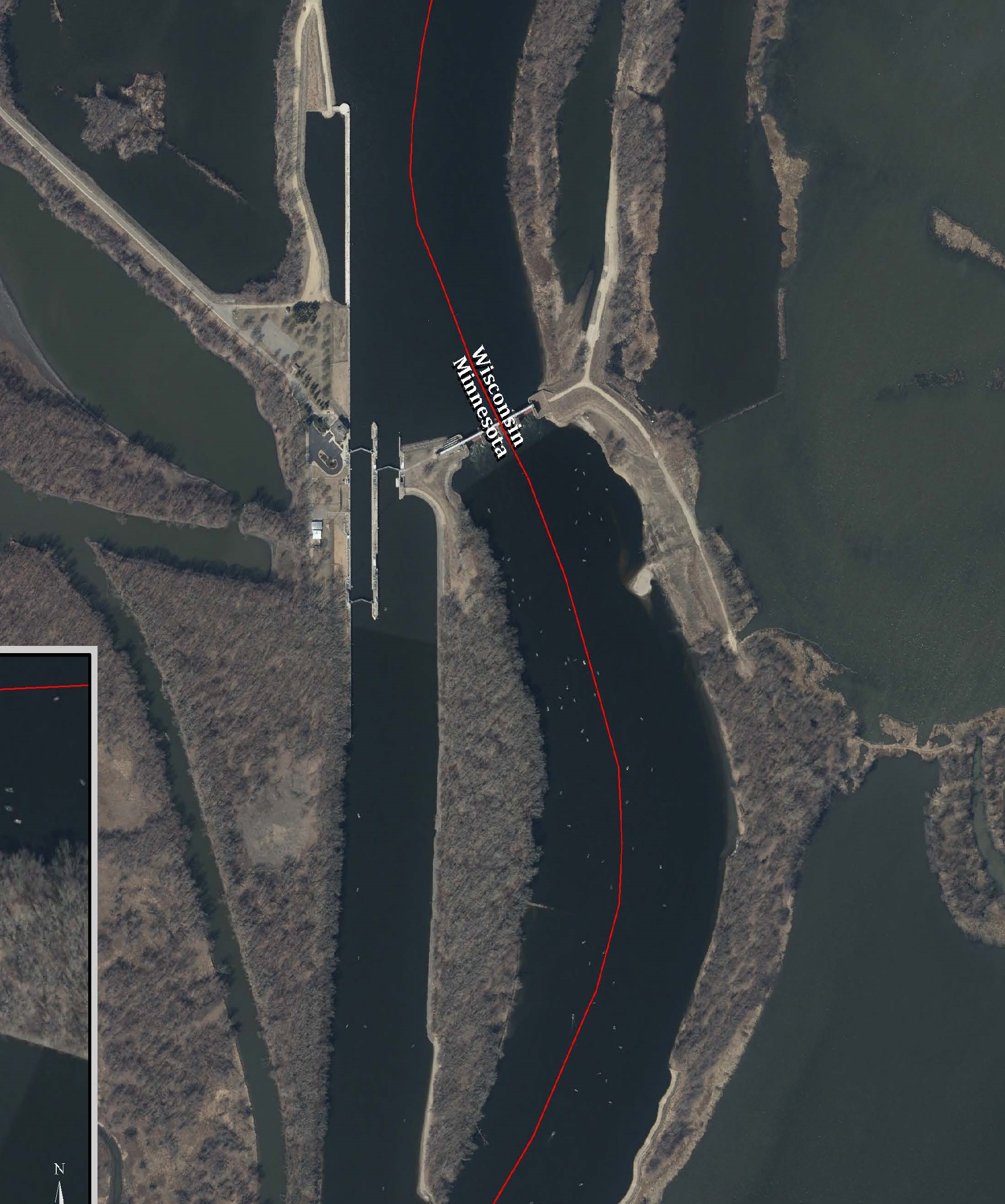
    I gave him the info I was told by the MN DNR. “The navigational channel on the LOCK side of the Y is split. Half MN and the other half WI” This would mean the whole area on the dam side is in WI and we are able to use 3 hooks.

    Upon turning on his ‘bird, the gps clearly showed the division on the dam side.

    I pulled out my cell and looked up the Navionics map which showed the division on the lock side as the DNR indicated.

    Does anyone have any info that would indicate where the heck it actually is?

    Jonesy
    Participant
    Posts: 1146
    #1603760

    Haha I always went off of what you said BK…. doah

    river rat randy
    Participant
    Hager City WI
    Posts: 1736
    #1603825

    Ok guys here is another conflict with the maps. The wardens go by a map of the wi/mn borders that was printed some time in the 1800s. I know this for sure, because I was given a map from a game warden [CO]. After we had a conflict over where I was Duck Hunting. I showed the maps to the warden my son had printed of a the internet from 2 different sites. He told me that my maps were incorrect. An where I was hunting that day I was illegal. I did not get a ticket, an a few days later he stop at my place an gave me a map that he had to go by. The only date I could fined on that map was 1895. It shows that all of Diamond Island is in Wi and ALL of WACOUTA BAY is in Wi. doah crazy ??? None of the modern maps show what the 1895 map does as far as Diamond Island an Wacouta Bay. shock …. rrr

    Brian Klawitter
    Keymaster
    Minnesota/Wisconsin Mississippi River
    Posts: 59940
    #1603842

    I take it this is NOT the border?

    That is not the border Doug.

    bullcans
    Participant
    Northfield MN
    Posts: 1937
    #1603850

    Ok guys here is another conflict with the maps. The wardens go by a map of the wi/mn borders that was printed some time in the 1800s. I know this for sure, because I was given a map from a game warden [CO]. After we had a conflict over where I was Duck Hunting. I showed the maps to the warden my son had printed of a the internet from 2 different sites. He told me that my maps were incorrect. An where I was hunting that day I was illegal. I did not get a ticket, an a few days later he stop at my place an gave me a map that he had to go by. The only date I could fined on that map was 1895. It shows that all of Diamond Island is in Wi and ALL of WACOUTA BAY is in Wi. doah crazy ??? None of the modern maps show what the 1895 map does as far as Diamond Island an Wacouta Bay. shock …. rrr

    But I thought that you actually helped in creating and drawing out that 1895 map Randy?
    rotflol rotflol rotflol lol just kidding! waytogo

    Brian Klawitter
    Keymaster
    Minnesota/Wisconsin Mississippi River
    Posts: 59940
    #1603851

    Well, I thought I did too.

    I’m not tossing the DNR employee under the bus because I may have miss understood him and looking at the Navionics map there is a dotted line were I was thinking it was. Course there’s a solid line in the dam area.

    Guess I’ll have to go to the horses mouth.

    doah

    Mike Klein
    Participant
    Hastings, MN
    Posts: 1026
    #1603853

    Google shows it on the dam side and diamond island is entirely in Wisconsin like randy said. Seems silly to me about diamond but the dam side makes sense. Well if you get caught and there is room for interpretation you would have a right to fight it and probably get off.

    Outdraft
    Participant
    Western Wi.
    Posts: 1149
    #1603854

    It’s just a guess but the Corp map is the guide

    Outdraft
    Participant
    Western Wi.
    Posts: 1149
    #1603855

    The nav channel divides the boundaries, or at least it used to

    Brian Klawitter
    Keymaster
    Minnesota/Wisconsin Mississippi River
    Posts: 59940
    #1603883

    Thanks Outdraft…I didn’t think I was going nuts.

    I pulled up the latest Corp map and it shows the boundry on the dam side.

    I’m checking in with the CO’s on both sides to see what they use.

    riverrat56
    Participant
    New Ulm, MN
    Posts: 175
    #1603887

    Is it possible that the lock side is split into both states possession to eliminate potential issues? Then the sliver of land between the Lock and Dam is MN again? Of course then the 2nd split would be center of the river channel. Stupid and ridiculous idea I know..but that wouldn’t stop of the state

    FishBlood&RiverMud
    Participant
    Prescott
    Posts: 6689
    #1603893

    It only makes sense that the lock side of the y is the boarder, since the dam side isn’t navigational through the dam; buy you can navigate through the locks…

    That’s the inky reason why I believed you Brian )

    nhamm
    Inactive
    Robbinsdale
    Posts: 7348
    #1603897

    Few years ago my Mom had a boyfriend who was one land surveyor for WI for the new bridge. The work put into to figuring out exactly where the line is was a huge deal.

    I sure hope you guys find an answer, but to officially claim something as a state agency they are gonna need to confirm with the books and as you guys saw with older maps, those books and records might be mighty old. Good luck!

    Brian Klawitter
    Keymaster
    Minnesota/Wisconsin Mississippi River
    Posts: 59940
    #1603917

    From the Corp of Engineers:

    We run into discrepancies between state maps in several locations on the river. It can be a problem for us because of course the boarder drives which state we may be getting a permit from. Anyway, we rely the 2014 U.S. Census Bureau’s database, as the official federal database, and if a state were to disagree, we would have them contact the Census Bureau to work it out. For LD 3, the boarder does run through the dam. I included a figure showing this.

    The navigation channel is the boundary in most areas, but is not in many and is not a reliable indicator.

    Steven J. Clark
    Chief, Environmental Compliance Section
    U.S. Army Corps of Engineers
    180 5th Street East, Suite 700
    St. Paul, MN 55101-1678

    Image from: 2014 U.S. Census Bureau Tiger Geodatabase

    I will add the above info is from the Corp and may or may not be used by enforcement. I’m waiting on a reply from the MN and WI CO’s that patrol Pool 4.

    Attachments:
    1. LD_3_Page_1.jpg

    Brian Klawitter
    Keymaster
    Minnesota/Wisconsin Mississippi River
    Posts: 59940
    #1603923

    Brian, the state boundary is on the roller gate side of the channel in that area. Part of the roller gate side is MN and part of it is WI. Thanks.
    Tyler Quandt
    Conservation Officer-Red Wing (MN)

    Brian Klawitter
    Keymaster
    Minnesota/Wisconsin Mississippi River
    Posts: 59940
    #1603925

    Brian,
    The border between MN/WI is on the roller side. The Lock side would be all MN water.

    Brad Peterson
    Conservation Warden Bureau of Law Enforcement
    Wisconsin Department of Natural Resources

    Brian Klawitter
    Keymaster
    Minnesota/Wisconsin Mississippi River
    Posts: 59940
    #1603930

    There it is from the guys that count.

    Justin Laack
    Participant
    Austin,mn
    Posts: 464
    #1604032

    Brian, the state boundary is on the roller gate side of the channel in that area. Part of the roller gate side is MN and part of it is WI. Thanks.
    Tyler Quandt
    Conservation Officer-Red Wing (MN)

    At which part of the roller gate does it switch to the other state. Would one assume the middle of the roller gate is the line??

    Brian Klawitter
    Keymaster
    Minnesota/Wisconsin Mississippi River
    Posts: 59940
    #1604048

    At which part of the roller gate does it switch to the other state. Would one assume the middle of the roller gate is the line??

    Looking at the enlarged image above, it looks like right smack down the middle.

    barc
    Participant
    SE MN
    Posts: 192
    #1604070

    I thought I could recall some discussions on the state boundary from back in the days of ‘Fish The River’. I remember it opened my eyes to the fact that the ‘middle of the navigation channel’ is not the state line in many instances and comes into play when the fish and game laws are not the same in the border states.

    I did a search and this thread from way back in December 2001 supports the information above.
    Link to thread…

    barc

    Brian Klawitter
    Keymaster
    Minnesota/Wisconsin Mississippi River
    Posts: 59940
    #1604078

    Lot’s has changed (and a lot hasn’t) since that post was made.

    But the border is still in the middle of the dam side.

    Thanks for sharing! Wonder what ever happened to “the warden”?

Viewing 26 posts - 1 through 26 (of 26 total)

You must be logged in to reply to this topic.