Humminbird Side Imaging reveals river structures

  • jhalfen
    Posts: 4179
    #1294823

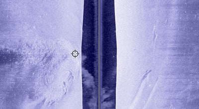
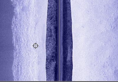
    Many river anglers are familiar with the fish-attracting abilities of man-made structures like wing dams and rip-rap shorelines. This past week, I had a chance to hook up with James Holst and Dustin Stewart to see how these river features are handled by Humminbird’s family of Side Imaging locators.

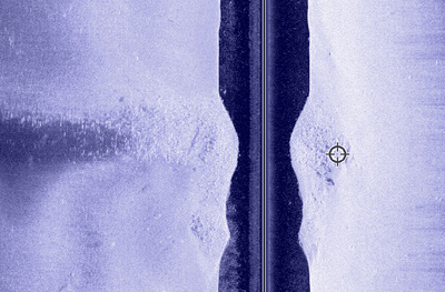
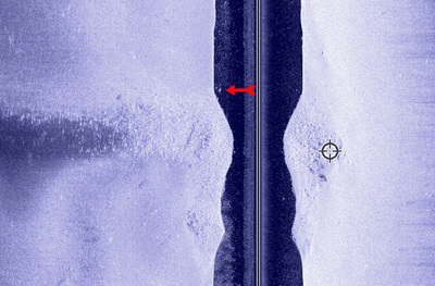
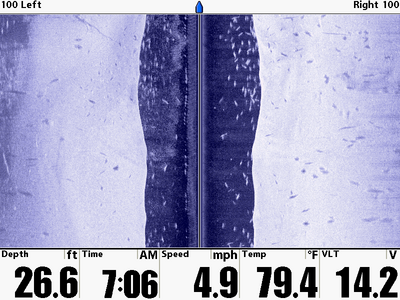
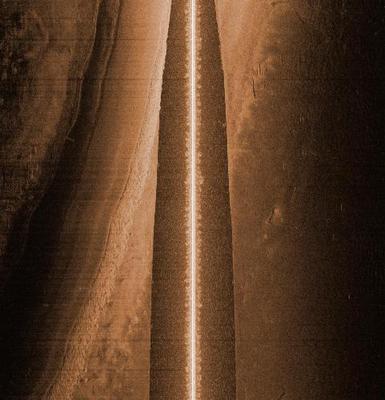
    This first image is a wingdam. You can see it extending from the left end of the image through the centerline, with the tip of the dam marked by the round cursor. I imaged this dam moving upstream at ~ 4.5 mph, so the upriver (front) face of the dam is up.

    Some cool things to note about this dam are (1) the small rockpile just downstream of the main body of the dam (below the dam, in these images), and (2) the fish (marked by the red arrow in the second image) sitting just where he’s supposed to be….in the slack water pocket at the base of the front face of the dam.

    Humminbird’s Side Imaging technology provided all of that information, including the shape of the dam, the precise lcoation of its tip, the neat rockpile just below the dam, and even fish relating to the dam….all in one upstream pass at 4.5 mph.

    Mike W
    MN/Anoka/Ham lake
    Posts: 13168
    #786719

    Lets see some wingdams Jason.

    Mike W
    MN/Anoka/Ham lake
    Posts: 13168
    #786723

    What is the importance of the speed you are reading at? Do you find a best speed to show the structure properly. Does to slow of speed stretch out the image?

    jhalfen
    Posts: 4179
    #786725

    Here’s another wingdam. I imaged this dam in the same manner as the one above….moving upstream past it at 4.5 mph. In this particular dam, the entire body of the dam is to the left of the boat’s path, so it only appears in the left side image.

    Some cool things to note about this dam are the anchor drag marks that are in the right side image, and also how the current swirling past the tip of the dam (again, marked by the circular cursor) has shaped the rock and sand downstream of the tip. It’s easy to see a couple of distinct circular patterns generated by the force of water moving rock and sand behind the dam.

    jhalfen
    Posts: 4179
    #786727

    Here’s how a rip-rap shoreline appears using Humminbird’s Side Imaging locators. I imaged this shoreline moving downstream. The shoreline itself is shown in dark blue along the left of the image, with rocks extending down the shore until they contact the sandy bottom of the river channel. The transition between the rip rap and the sand bottom is marked by the circular cursor. At certain times of the year, we HAMMER walleye and sauger by dragging light plastics or livebait right along this transition, which deflects enough current to hold feeding gamefish.

    James Holst
    Keymaster
    SE Minnesota
    Posts: 18924
    #786728

    The wing dam in Jason’s first photo has given up dozens, perhaps hundreds, of fish on guided trip for Dustin and I over the years. And I would bet the vast majority of those fish have come from the rock pile that is built up just downstream from the tip of that dam.

    Thanks for the on the water demo, J. We definitely learned a lot of new info in a short morning of scouting on a body of water we’ve been fishing for a long time.

    jhalfen
    Posts: 4179
    #786729

    What thread of Side Images would be complete without some good images of fish?

    Here’s one that we captured the other day. Maybe we should have a contest to see who can guess the number of fish shown in this image. I wish I could repeat some of the things that were said in the boat when we saw this image live…but this is a family show so I’ll omit them for now.

    jhalfen
    Posts: 4179
    #786730

    Quote:


    What is the importance of the speed you are reading at? Do you find a best speed to show the structure properly. Does to slow of speed stretch out the image?


    Mike, it is possible to collect clear, easy to interpret Side Images at speeds from 1-6 mph. It is important, however, that the locator’s chart speed is adjusted to correlate with the boat’s speed. At a speed of 4-5 mph, I collect my clearest images (like the ones shown here) at a chart speed of 3-4 (out of 10). When I slow down to pull cranks or spinners, I’ll use a chart speed of 1-2.

    If there is a mismatch between chart speed and boat speed, then the objects in the side images appear either stretched out (chart speed too fast) or squished (chart speed too slow).

    Czech
    Cottage Grove, MN
    Posts: 1574
    #786733

    Ok you guys, help out us SI newbees here. How the heck do you interpret the images? Do I have to tilt my head 90 degrees? I’m sure I missed a SI 101 here sometime, but I’ve got sea legs right now and tilting my head is not an option. Thanks!

    James Holst
    Keymaster
    SE Minnesota
    Posts: 18924
    #786735

    Quote:


    Ok you guys, help out us SI newbees here. How the heck do you interpret the images? Do I have to tilt my head 90 degrees? I’m sure I missed a SI 101 here sometime, but I’ve got sea legs right now and tilting my head is not an option. Thanks!


    No need to tilt your head. Imagine you’re looking face down into clear water with each eye seeing off to the side a little. You do not see what is directly below you… that is what 2D (down look) sonar is for. That “dead” area is represented by the dark stripe down the center of the screen from top to bottom. Your left eye sees off to the left side of the boat (dark stripe) and your right eye sees off to the right of the boat. So basically think of it as you’re laying down on the bottom of the boat, looking down, with your nose running down the center of that dark strip in the images. In the image I linked from Jason’s first post we’re driving upstream to side scan a wing dam with the intention of staying outside of it. Instead we clipped the end of it so that’s why most of the wing dam appears on the left hand side and a small portion appear on the right hand side.

    Does that help your perspective at all?

    Czech
    Cottage Grove, MN
    Posts: 1574
    #786746

    Yep! Thanks James, I’ve just had many questions, both myself and others about how to interpret SI images. So on the first picts on this thread, the left one is a wing or a channel? Is darker color higher in the water column or vis versa? Can you magnify resolution? Meaning the fish appear tiny, can you take a closer look? I’ve seen some shots of cribs with the shadows behind and fish there, way too cool. Now I have to find a few extra bucks and talk to the wife, Father’s Day is past already, correct? Darn, my luck.

    KirtH
    Lakeville
    Posts: 4063
    #786760

    Jason what SD card are you using to capture photos, I need to pick one up, these things are amazing, trolling on Pepin last weekend, had the SI on and noted that that where fish out deeper and suspended spun around and had a couple of nice sauger grace my boat

    Bob Schultz
    Wausau,Wi
    Posts: 744
    #786762

    Did you find out what species all those fish were?

    camodm
    Wisconsin
    Posts: 167
    #786768

    Get report. Sounds like you guys had a great day on the water. I’m writing this on the dock at Everts, still waiting to get picked up……………………..

    whittsend
    Posts: 2389
    #786806

    White bass school? Carp? Any idea what kind of fish were marked in your screenshot? I assume they aren’t walleye or sauger based on how high they are riding.

    You guys didn’t happen to mark “Pepie” the Pepin monster, did you??

    jhalfen
    Posts: 4179
    #786807

    Quote:


    So on the first picts on this thread, the left one is a wing or a channel? Is darker color higher in the water column or vis versa? Can you magnify resolution? Meaning the fish appear tiny, can you take a closer look?


    Lots of questions here, let me see if I can tackle them:

    1. The first side image shows a wingdam extending from the left hand margin (which is close to the shore), running beneath the boat (note that you see the dam in both images, so I ran over the top of it), and terminating in the right side iamge, meaning that the tip was to the right of the boat’s path as I drove over the dam.

    2. Which darker color are you referring to? On the dam, the darkest part is on the very shallowest portion, where the sonar signal is prevented from seeing what is beyond the shallowest part. In the rip rap picture, the darkest portion is the shoreline itself…no signal can penetrate beyond the shore.

    3 and 4. You can magnify the picture on the water using the zoom key. When you press the zoom key, the image freezes, and a small zoom window appears on the screen. You can move that window around using the 4-way arrow key, allowing you to magnify any portion of the image. You can also download your screen captures and zoom in using a photo utility (as I’ve done here).

    jhalfen
    Posts: 4179
    #786808

    Quote:


    White bass school? Carp? Any idea what kind of fish were marked in your screenshot? I assume they aren’t walleye or sauger based on how high they are riding.


    Beats me….probably some walleyes mixed in there based on prior experience. We didn’t break the rods out until later on in the day; the morning was strictly a Side Imaging trip.

    jhalfen
    Posts: 4179
    #786810

    Quote:


    Jason what SD card are you using to capture photos, I need to pick one up, these things are amazing.


    Kirt, I use Kodak SD cards….although I doubt that there will be much difference in performance from one brand to another. These are relatively small, low-resolution files being written to the cards, so I wouldn’t expect the rate of data transfer to be that big of an issue.

    wade_kuehl
    Northwest Iowa
    Posts: 6167
    #786881

    Great job, Jason! Much appreciated!

    WarrenMN2
    Posts: 53
    #787026

    Hope you don’t mind me jumping in. They work good up here at Devils Lake too. An old road that parallel’s the current shore. One thing about SD cards, there is a difference. I’ve found the SanDisk Extreme III’s are about the only way to go if you do any recordings. I picked up PNY’s the other day and they slowed the system down too much.

    I included the DrDepth image from that area I’m presently working on. I think you should be able to make out the old road bed. Funny thing is is I never see any one fishing the rip rap on the one side. All I’ve seen while there are up in the trees. Oh well.

    WarrenMN

Viewing 21 posts - 1 through 21 (of 21 total)

You must be logged in to reply to this topic.